

Sakshi Education
There is no civilisation without water. The very existential contributor to human life on Earth is water.
Out of the total water available, we utilise only 1 percent of it and that it is not available to all. To control the flow of water and make the best use of it, water works have been taken up since the beginning of human civilisations.
The Ancient Egyptians, Babylonians, Romans, Cholas, and virtually every civilisation have built canals and dams to irrigate their farmlands. In the modern era, the Colorado River Aqueduct (US), the National Water Carrier (Israel), the Cutzamala System (Mexico), and the as yet incomplete South-North Water Transfer Project (China) are examples of large national inter-basin transfer (IBT) projects aimed at improving agriculture, alleviating floods, and providing drinking water to parched areas. Now India is likely to join this league by restarting its National River Linking Project (NRLP).
Need for Inter Basin Water Transfer
The rainfall of India is primarily orographic, associated with tropical depressions originating in the Arabian Sea and the Bay of Bengal. The summer monsoon accounts for more than 85 per cent of the precipitation. The uncertainty of occurrence of rainfall marked by prolonged dry spells and fluctuations in seasonal and annual rainfall is a serious problem for the country. Large parts of Haryana, Maharashtra, Andhra Pradesh, Rajasthan, Gujarat, Madhya Pradesh, Karnataka and Tamil Nadu are not only in deficit in rainfall but also subject to large variations, resulting in frequent droughts and causing immense hardship to the population and enormous loss to the nation. This has been major cause of grief for farming community, which forms about 55% of the country’s population. The water availability even for drinking purposes becomes critical, particularly in the summer months as the rivers dry up and the ground water recedes. Regional variations in the rainfall lead to situations when some parts of the country do not have enough water even for raising a single crop. On the other hand excess rainfall occurring in some parts of the country creates havoc due to floods.
Irrigation using river water and ground water has been the prime factor for raising the food grain production in our country from a mere 50 million tonnes in the 1950s to more than 200 million tonnes at present, leading us to attain self sufficiency in food. Irrigated area has increased from 22 million hectares to 95 million hectares during this period. The population of India, which is around 1000 million at present, is expected to increase to 1500 to 1800 million in the year 2050 and that would require about 450 million tonnes of food grains. For meeting this requirement, it would be necessary to increase irrigation potential to 160 million hectares for all crops by 2050. India's maximum irrigation potential that could be created through conventional sources has been assessed to be about 140 million hectares. For attaining a potential of 160 million hectares, other strategies shall have to be evolved.
Floods are a recurring feature, particularly in Brahmaputra and Ganga rivers, in which almost 60 per cent of the river flows of our country occur. Flood damages, which were Rs. 52 crores in 1953, have gone up to Rs. 5,846 crores in 1998 with annual average being Rs. 1,343 crores affecting the States of Assam, Bihar, West Bengal and Uttar Pradesh along with untold human sufferings. On the other hand, large areas in the States of Rajasthan, Gujarat, Andhra Pradesh, Karnataka and Tamil Nadu face recurring droughts. As much as 85 percentage of drought prone area falls in these States.
One of the most effective ways to increase the irrigation potential for increasing the food grain production, mitigate floods and droughts and reduce regional imbalance in the availability of water is the Inter Basin Water Transfer (IBWT) from the surplus rivers to deficit areas. Brahmaputra and Ganga particularly their northern tributaries, Mahanadi, Godavari and West Flowing Rivers originating from the Western Ghats are found to be surplus in water resources. If we can build storage reservoirs on these rivers and connect them to other parts of the country, regional imbalances could be reduced significantly and lot of benefits by way of additional irrigation, domestic and industrial water supply, hydropower generation, navigational facilities etc. would accrue.
History of NRLP
Linkage of rivers has been proposed as a solution for this problem since the independence. The water is main input to the agriculture and also an important element for the life of human kind, its optimal utilization is necessary. In India, the first idea of river linkage was proposed by Sir Author Cotton, who is famous for the completion of Dowleswaram Barrage on Godavari river. Though, the idea interested then governor general, Lord Dalhousie, it didn’t go forward due to want of funding.
The idea was revived after nine decades by young engineer and pilot Captain Dinshaw J. Dastur. In his plan, Capt. Dastur initiated the concept of a “Garland Canal” around the Himalayan, Central and Peninsular India. Impressed with his plan, his friend Homi Bhabha got him an introduction to Jawaharlal Nehru. But due to post-partition problems, the plan was shelved. Meanwhile, the famous civil engineer and the then irrigation Minister Dr. K.L. Rao came up with his own plan to interlink of rivers by connecting the Ganga with the Cauvery river in the year 1972.
In 1977, the Morarji Desai government revived the Dastur plan. The Government of India was enthusiastic enough that it approached the Food & Agriculture Organisation in Rome to examine the proposed project. Ninety experts from all over the world scrutinised the plans, and approved of them. Unfortunately, by then the Desai ministry had lost power -- and the linking scheme was again forgotten.
The proposals although received very good response from all sectors of communities throughout, but not found techno-economical feasible for implementation. In 1980, the then Ministry of Irrigation (now Ministry of Water Resources) and Central Water Commission formulated a National Perspective Plan (NPP) for Water Resources Development in 1980, envisaging inter basin transfer of water from surplus basins to deficit ones with a view to minimize the regional imbalances and optimally utilize the available water resources. Despite such long-standing interest, there has been no tangible progress achieved on linkage of rivers due to lack of attention from the governments. Now, the NDA government is again pitching for implementation of the project.
Details of NRLP
The National River Linking Project (NRLP) is aimed at constructing 30 river links, 3,000 storage structures, a canal network of almost 15,000 kms, generation of 34 GW of hydroelectric power, creation of 87 million acres of irrigated land and would transfer a huge 174 trillion litres of water per annum.
About 33% of India around its northern river basins has access to 62% of the country's annual freshwater while the remaining 67% of the country in the south and west have to make do with the remaining 38% of the water. Linkage of rivers would arrest the drought that continuously troubles the Western and Southern parts of India.
One of the important objectives of the project is to divert the flow of two large rivers of the country Ganga and Bramhaputra by interlinking them. If this idea comes true, the NRLP would be four times larger than China's ongoing multi-decade project and largest river linking project in the world. According to Price Index of 2002, the total cost of the NRLP is estimated to be Rs. 5.6 lakh crore and the project will displace about 5,80,000 people.
National Perspective Plan comprises of two components viz. Himalayan Rivers Development and Peninsular Rivers Development. In the proposals of NPP, the transfer of water has been proposed mostly by gravity; lifts were kept minimal and confined to around 120 m and only surplus flood water after meeting all in-basin requirements in foreseeable future has been planned for transfer to water deficit areas.
Himalayan Rivers Development
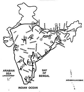
Himalayan Rivers Development Component envisages construction of storage reservoirs on the principal tributaries of Ganga and Brahmaputra rivers in India, Nepal and Bhutan along with interlinking of river systems to transfer surplus flows of the eastern tributaries of the river Ganga to the west, apart from linking of the main Brahmaputra and its tributaries with Ganga and Ganga with the river Mahanadi.
Proposed Inter Basin Water Transfer Links – Himalayan Component
Peninsular Rivers Development is divided into four major parts viz.
Linking of rivers is not an idea of modern times as it appears; indeed its roots can be traced back to some of the ancient civilisations of the world. All agrarian societies husbanded water resources by building dams over rivers and canals. Water storage through tanks was another mode of water usage. In India, a dam that was built in 2nd century on Cauvery river had worked until the mid of 19th century and watered about 25,000 hectares of land. Cholas, Pandyas, Vijayanagara and Kakatiya Kings supplied irrigation water by diverting the flows of Cauvery, Tungabhadra and Vaigai rivers. Mughal emperors built the Western Yamuna and Agra canals. Sir Author Cotton, the father of modern irrigation in India, constructed dams on Krishna and Godavari rivers. In recent times, the Telugu Ganga project is supplying potable water to Chennai city.
Several Europe and North American countries also river linking project have been implemented. The Europe Canal, which connects the Rhine and Danube rivers, was completed in 1992. This also connects North Sea with Atlantic Ocean. The canal is being used for the purposes of navigation, production of power, supply of water for agricultural and industrial production. Illinois river canal link, the Tennessee-Tombigbee river link and Gulf Intracoastal Waterway are rendering their efficient services. Marne-Rhone rivers linkage through a canal in France is another successful example of river linking in the world.
Benefits of River Linking
The success of National River Linking Project
depends on so many factors, which have to be carefully taken into factor integrated into the planning and implementation of the project. Particularly the states that have excess water flows shall give their consent to shift them to other states. They may be reluctant to give such nod eyeing their future needs. Political interests of the parties will complicate the entire issue. The project will succeed only if geological, hydrological and regional conditions are appropriately positioned. The environmental safeguards shall be implemented meticulously. All the departments shall be coordinated properly to complete this gigantic project. Though river linking is great idea, its execution is fraught with myriad problems.
The Ancient Egyptians, Babylonians, Romans, Cholas, and virtually every civilisation have built canals and dams to irrigate their farmlands. In the modern era, the Colorado River Aqueduct (US), the National Water Carrier (Israel), the Cutzamala System (Mexico), and the as yet incomplete South-North Water Transfer Project (China) are examples of large national inter-basin transfer (IBT) projects aimed at improving agriculture, alleviating floods, and providing drinking water to parched areas. Now India is likely to join this league by restarting its National River Linking Project (NRLP).
Need for Inter Basin Water Transfer
The rainfall of India is primarily orographic, associated with tropical depressions originating in the Arabian Sea and the Bay of Bengal. The summer monsoon accounts for more than 85 per cent of the precipitation. The uncertainty of occurrence of rainfall marked by prolonged dry spells and fluctuations in seasonal and annual rainfall is a serious problem for the country. Large parts of Haryana, Maharashtra, Andhra Pradesh, Rajasthan, Gujarat, Madhya Pradesh, Karnataka and Tamil Nadu are not only in deficit in rainfall but also subject to large variations, resulting in frequent droughts and causing immense hardship to the population and enormous loss to the nation. This has been major cause of grief for farming community, which forms about 55% of the country’s population. The water availability even for drinking purposes becomes critical, particularly in the summer months as the rivers dry up and the ground water recedes. Regional variations in the rainfall lead to situations when some parts of the country do not have enough water even for raising a single crop. On the other hand excess rainfall occurring in some parts of the country creates havoc due to floods.
Irrigation using river water and ground water has been the prime factor for raising the food grain production in our country from a mere 50 million tonnes in the 1950s to more than 200 million tonnes at present, leading us to attain self sufficiency in food. Irrigated area has increased from 22 million hectares to 95 million hectares during this period. The population of India, which is around 1000 million at present, is expected to increase to 1500 to 1800 million in the year 2050 and that would require about 450 million tonnes of food grains. For meeting this requirement, it would be necessary to increase irrigation potential to 160 million hectares for all crops by 2050. India's maximum irrigation potential that could be created through conventional sources has been assessed to be about 140 million hectares. For attaining a potential of 160 million hectares, other strategies shall have to be evolved.
Floods are a recurring feature, particularly in Brahmaputra and Ganga rivers, in which almost 60 per cent of the river flows of our country occur. Flood damages, which were Rs. 52 crores in 1953, have gone up to Rs. 5,846 crores in 1998 with annual average being Rs. 1,343 crores affecting the States of Assam, Bihar, West Bengal and Uttar Pradesh along with untold human sufferings. On the other hand, large areas in the States of Rajasthan, Gujarat, Andhra Pradesh, Karnataka and Tamil Nadu face recurring droughts. As much as 85 percentage of drought prone area falls in these States.
One of the most effective ways to increase the irrigation potential for increasing the food grain production, mitigate floods and droughts and reduce regional imbalance in the availability of water is the Inter Basin Water Transfer (IBWT) from the surplus rivers to deficit areas. Brahmaputra and Ganga particularly their northern tributaries, Mahanadi, Godavari and West Flowing Rivers originating from the Western Ghats are found to be surplus in water resources. If we can build storage reservoirs on these rivers and connect them to other parts of the country, regional imbalances could be reduced significantly and lot of benefits by way of additional irrigation, domestic and industrial water supply, hydropower generation, navigational facilities etc. would accrue.
History of NRLP
Linkage of rivers has been proposed as a solution for this problem since the independence. The water is main input to the agriculture and also an important element for the life of human kind, its optimal utilization is necessary. In India, the first idea of river linkage was proposed by Sir Author Cotton, who is famous for the completion of Dowleswaram Barrage on Godavari river. Though, the idea interested then governor general, Lord Dalhousie, it didn’t go forward due to want of funding.
The idea was revived after nine decades by young engineer and pilot Captain Dinshaw J. Dastur. In his plan, Capt. Dastur initiated the concept of a “Garland Canal” around the Himalayan, Central and Peninsular India. Impressed with his plan, his friend Homi Bhabha got him an introduction to Jawaharlal Nehru. But due to post-partition problems, the plan was shelved. Meanwhile, the famous civil engineer and the then irrigation Minister Dr. K.L. Rao came up with his own plan to interlink of rivers by connecting the Ganga with the Cauvery river in the year 1972.
In 1977, the Morarji Desai government revived the Dastur plan. The Government of India was enthusiastic enough that it approached the Food & Agriculture Organisation in Rome to examine the proposed project. Ninety experts from all over the world scrutinised the plans, and approved of them. Unfortunately, by then the Desai ministry had lost power -- and the linking scheme was again forgotten.
The proposals although received very good response from all sectors of communities throughout, but not found techno-economical feasible for implementation. In 1980, the then Ministry of Irrigation (now Ministry of Water Resources) and Central Water Commission formulated a National Perspective Plan (NPP) for Water Resources Development in 1980, envisaging inter basin transfer of water from surplus basins to deficit ones with a view to minimize the regional imbalances and optimally utilize the available water resources. Despite such long-standing interest, there has been no tangible progress achieved on linkage of rivers due to lack of attention from the governments. Now, the NDA government is again pitching for implementation of the project.
Details of NRLP
The National River Linking Project (NRLP) is aimed at constructing 30 river links, 3,000 storage structures, a canal network of almost 15,000 kms, generation of 34 GW of hydroelectric power, creation of 87 million acres of irrigated land and would transfer a huge 174 trillion litres of water per annum.
About 33% of India around its northern river basins has access to 62% of the country's annual freshwater while the remaining 67% of the country in the south and west have to make do with the remaining 38% of the water. Linkage of rivers would arrest the drought that continuously troubles the Western and Southern parts of India.
One of the important objectives of the project is to divert the flow of two large rivers of the country Ganga and Bramhaputra by interlinking them. If this idea comes true, the NRLP would be four times larger than China's ongoing multi-decade project and largest river linking project in the world. According to Price Index of 2002, the total cost of the NRLP is estimated to be Rs. 5.6 lakh crore and the project will displace about 5,80,000 people.
National Perspective Plan comprises of two components viz. Himalayan Rivers Development and Peninsular Rivers Development. In the proposals of NPP, the transfer of water has been proposed mostly by gravity; lifts were kept minimal and confined to around 120 m and only surplus flood water after meeting all in-basin requirements in foreseeable future has been planned for transfer to water deficit areas.
Himalayan Rivers Development
Himalayan Rivers Development Component envisages construction of storage reservoirs on the principal tributaries of Ganga and Brahmaputra rivers in India, Nepal and Bhutan along with interlinking of river systems to transfer surplus flows of the eastern tributaries of the river Ganga to the west, apart from linking of the main Brahmaputra and its tributaries with Ganga and Ganga with the river Mahanadi.
Proposed Inter Basin Water Transfer Links – Himalayan Component
- Manas-Sankosh-Tista-Ganga
- Kosi-Ghaghra
- Gandak-Ganga
- Ghaghra-Yamuna
- Sarada-Yamuna
- Yamuna-Rajasthan
- Rajasthan-Sbarmati
- Chunar-Sone Barrage
- Sone Dam-Southern Tributaries of Ganga
- Ganga (Farakka)-Damodar-Subernarekha
- Subernarekha-Mahanadi
- Kosi -Mechi
- Farakka –Sunderbans
- Jogighopa-Tista-Farakka (Alternative to first one)
Peninsular Rivers Development is divided into four major parts viz.
- Interlinking of Mahanadi-Godavari-Krishna-Cauvery rivers and building storages at potential sites in these basins.
This part involves interlinking of the major river systems where surpluses from the Mahanadi and the Godavari are intended to be transferred to the needy areas in the south, through Krishna and Cauvery rivers.
- Interlinking of west flowing rivers, north of Bombay and south of Tapi.
This scheme envisages construction of as many optimal storages as possible on these streams and interlinking them to make available appreciable quantum of water for transfer to areas where additional water is needed. The scheme provides for taking water supply canal to the metropolitan areas of Mumbai; it also provides irrigation in the coastal areas in Maharashtra
- Interlinking of Ken-Chambal
The scheme provides for a water grid for Madhya Pradesh, Rajasthan and Uttar Pradesh and interlinking canal backed by as much storage as possible.
- Diversion of other west flowing rivers
The high rainfall on the western side of the Western Ghats runs down into numerous streams which discharge into the Arabian Sea. The construction of an interlinking canal system backed up by adequate storages could be planned to meet all requirements of Kerala as also for transfer of some waters towards east to meet the needs of drought affected areas.
- Mahanadi-Godavari (Dowleswaram)
- Godavari - Krishna (Pulichintala)
- Godavari - Krishna (Vijayawada)
- Krishna (Almatti)- Penna
- Godavari-Krishna (Nagarjuna Sagar)
- Krishna (Srisailam)- Krishna
- Krishna - Penna (Somasila)
- Penna - Cauvery
- Cauvery (Kattalai) - Vaigai – Gundar
- Ken - Betwa
- Parvati- Kalisindh-Chambal
- Par-Tapti-Narmada
- Daman Ganga -Pinjal
- Bedti (Gangavalli)-Wardha
- Netravati-Hemavati
- Pamba-Achankovil-Vaippar
Linking of rivers is not an idea of modern times as it appears; indeed its roots can be traced back to some of the ancient civilisations of the world. All agrarian societies husbanded water resources by building dams over rivers and canals. Water storage through tanks was another mode of water usage. In India, a dam that was built in 2nd century on Cauvery river had worked until the mid of 19th century and watered about 25,000 hectares of land. Cholas, Pandyas, Vijayanagara and Kakatiya Kings supplied irrigation water by diverting the flows of Cauvery, Tungabhadra and Vaigai rivers. Mughal emperors built the Western Yamuna and Agra canals. Sir Author Cotton, the father of modern irrigation in India, constructed dams on Krishna and Godavari rivers. In recent times, the Telugu Ganga project is supplying potable water to Chennai city.
Several Europe and North American countries also river linking project have been implemented. The Europe Canal, which connects the Rhine and Danube rivers, was completed in 1992. This also connects North Sea with Atlantic Ocean. The canal is being used for the purposes of navigation, production of power, supply of water for agricultural and industrial production. Illinois river canal link, the Tennessee-Tombigbee river link and Gulf Intracoastal Waterway are rendering their efficient services. Marne-Rhone rivers linkage through a canal in France is another successful example of river linking in the world.
Benefits of River Linking
- The agricultural output will increase 100 per cent in coming five years. This would by and large prevent the occurrence of famine in India.
- Due inter-basin water ways, crude oil usage will come down, which will save a lot of valuable foreign exchange.
- Thanks to the improved food security, country’s security scenario will improve.
- About 4lakh new jobs will be created in coming 10 years.
- The frequent occurrence of floods in North and North-eastern India can be mitigated.
- Water paucity issues can be very well addressed.
- Development of transportation through waterways.
- The annual average income of farmers may rise from present Rs. 2,500 per acre to Rs. 30,000.
- Large scale deforestation and resultant soil erosion will cause very high environmental damage.
- Rehabilitation of the displaced is always a problem. The social and political unrest will be crated due to the problems in implementation of the project.
- Our relations with Pakistan and Bangladesh will be hampered.
- It is a myth that rivers in North and North-eastern India have excessive waters. Most of the basins are making full use of the available water. The ongoing disputes between the rural-based farming communities and urban-based industrial manufacturers indeed suggest lack of water availability. A recent study made it clear that there are no excessive waters in Mahanadi. If that turns out to be true, then there is no point in linking it with Godavari.
- It is impossible to shift the flood water to other rivers because at the same time the other river would also have the flood. Even if the water is shifted, large reservoirs need to be built in order to store the water. This requires making elaborate arrangements and construction of such large-scare reservoirs affects the ecological balance. Besides that, governments always fail to rehabilitate the displaced in proper fashion.
- It is true that the investment over water resources management will yield good results. The question, however, how efficiently governments can execute the construction of those projects.
- The argument that increased usage of water is the reason for shortage cannot be accepted. The technical and administrative problems in water distribution are the main reasons for water shortages. The water problems can be solved by addressing these issues by governments.
- The rain water can be harvested by constructing percolation pits. The rain water captured from the roof tops can be used for local needs. The decentralisation of water collection and conservation processes and construction of check dams will increase the water availability at local level. It doesn’t require mega dams and construction of link canals.
- River linking project’s main objective is to shift the flood water to the downward rivers. However, Ganga, Bramhaputra rivers get their flood waters between July and October. The South India, which faces water scarcity, needs water flows between January and May. In order make the waters available when required, large water bodies to preserve the water. Are we ready to bear the social, economic and environmental costs in exchange the increased water flow?
- Though floods cause economic loss, they improve productivity levels of the land by bringing fertile soil. Any artificial arrangement that prevents floods will turn the land swathes into infertile lands. This would further hamper the production of food grains.
- Due to the floods, the contaminating materials that always fill the Ganga are washed away into the sea. Linkage of rivers would reduce the speed of Ganga current and waste material would inflict more pain on the river ecosystem.
- To successfully implement NRLP, about 8,000 sq.km land is required. Is it possible to pool such a vast amount of land? The farmers and environmentalists will entangle the land pooling process by litigating the government decisions. And it is also not easy to provide alternative land to the people whose lands would be confiscated for this project. Indeed, we don’t have such amount of additional land.
The success of National River Linking Project
depends on so many factors, which have to be carefully taken into factor integrated into the planning and implementation of the project. Particularly the states that have excess water flows shall give their consent to shift them to other states. They may be reluctant to give such nod eyeing their future needs. Political interests of the parties will complicate the entire issue. The project will succeed only if geological, hydrological and regional conditions are appropriately positioned. The environmental safeguards shall be implemented meticulously. All the departments shall be coordinated properly to complete this gigantic project. Though river linking is great idea, its execution is fraught with myriad problems.
Published date : 16 Feb 2015 05:15PM