

Chapter - 1
INDIA - RELIEF FEATURES
I Key Points:
- India lies totally in the Northern Hemisphere of the globe.
- India mainland lies between 80.41 and 370.61 North latitudes and 680.71 and 970.251 East longitudes.
- For India the central longitude 820.301 East is taken as Standard Maridian.
- India Standard Time (IST) is 5 ½ hours a head Greenwich Mean Time(GMT).
- World land forms originated from Angara land (Laurasia) and Gondwanaland.
- The India peninsula was part of Gondwanaland.
- India plate moved North - East and Collided Eurasian plate resulting the formation of the Himalayas.
- Greater Himalayas average height is 6100 mts.
- The Pirpanjal and Mahabharata ranges are in the part of lesser Himalayas.
- Valley of Kashmir, the Kangra and Kulu , Hill Stations Simla , Mussorie , Nainital, Raniket are in lesser Himalayas.
- The Valleys lying between the Himachal and Shivaliks are Duns. The prominent Duns are Dehradun, Kotli Dun Patli Dun.
- The eastern most boundary of the Himalayas is the Brahmaputra valley.
- The divisions of the Himalayas in Arunachal Pradesh beyond the Dihang valley is known as Purvanchal.
- Regionally the purvanchal are known as patkai hills, the Naga hills, Manipuri hills, Khasi and Mizo hills.
- The Himalayas are reason for summer rains and monsoon type climate in India.
- 'Doab' means two rivers. In the western part of great northern plain the 'Doab' features dominate the fertile land.
- Ganga plain extends from the rivers Ghaggar to Teesta.
- Gravel and pebble sediments feature is known as ' Bhabar' .
- Swampy and Marshy region called Terai.
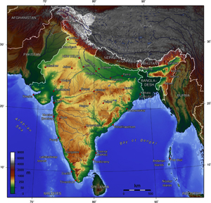
- The Southern most tip of the Peninsular Plateau is Kanyakumari .
- The India Plateau is slightly tilted towards east.
- Chotanagpur plateau is rich mineral resources .
- Western Ghats, Eastern Ghats and Nilgiris form Western , Eastern and Southern boundaries to the Deccan plateau.
- The famous hill Station Udagamandalam, popularly known as Ooty, is located in Nilgiris.
- Doda Betta (2637 mts) is the highest peak in western Ghats.
- The highest peak in Eastern Ghats is Aroya Konda found at Chinthapalli (1680 mts , in the A.P ).
- The Peninsular plateau is formed with black soils due to volcanic activity.
- The Thar Desert is located on the leeward side of Aravalis.
- The Thar Desert receives very low amount of rainfall (100 to 150 mm per year)
- 'Luni' is the only river in the Thar Desert.
- 'Indira Gandhi Canal' is the longest canal in Country (650 kms) watering part of the Thar desert.
- The western coast starts from the Rann of kutch and ends at Kanya Kumari.
- Lake Kolleru and Pulicat are in Andhra Pradesh.
- In Andaman and Nicobar, Narkondam and Barren are volcanic origin.
- The Southernmost tip India is found in Nicobar called as ' Indira Point' .
II Concepts
-
Perennial: Continuing throughout the entire year as a stream. The seasonal cycle of accumulation of ice, movement and melting of Greater Himalayas.
-
Coral reefs: Under water Structure made from calcium and carbonate secreted by corals. Corals is an animal that lives under the sea on the bed and lives on a skeleton that it has created. Coral begins out as a small polpup and attaches it self to a good spot and then starts creating a skeliton to live on coral gets food by algae , algae are attracted to the skelital structure because for the algae to live.
-
Coastal Plains: A plain adjacent to a coast is called coastal plain. The southern part of the peninsular is borded by narrow costal strips along the Arabian Sea on the west and the Bay of Bangal on the east.
-
Peninsula: A Place/ Piece of the which is surrounded by water on three sides. But connected the main land on the side. The peninsular plateau is a table land composed of the old crystalline, igneous and metamorphic rocks. It was formed due to the breaking and drifting of the Gondwanaland and thus making it a part of the oldest landmass.
-
Lauraisa: Laura sia was the northernmost of two continents that formed part of the Pangaea - super continent from approximately 200 million years ago. World land forms originated from two gaint lands namely Angara land ( Laurasia) and Gondwanaland.
-
Duns: The longitudinal valley lying between Himalaya and the shiwaliks are known as 'Duns' . Dehra Dum, kothi Dum and pathi Dum are some of the well - Known Duns.
-
Angaraland: The landmass to the north of Tethys sea was called Angara land . Ancient continental mass consisted of modern continents of Asia and Europe.
-
Gondwana land: The land mass to the South of Tethys sea was called Gondwanaland . Ancient continental mass consisted south America , Africa, India , Australia and Aritartica.
-
Shivalik: The Southern most range of Himalayas . A mountain rage of the outer Himalayas.
-
Purvanchal: In Arunachal Pradesh beyond the Dihang valley , the Himalayas take hair pin bend to the south and act as eastern boundary of India and run through the north eastern states. These division are known as "Purvanchal ".
- Leeward: To wards the side sheltered from the wind is leeward.
Questions and Answers
- Which are the major physiographic divisions of India ? Contrast the relief of the Himalayas region with that of the peninsular plateau?
I. The Major Physiographic divisions of India : The relief divisions of India landmass can be divided in to the following groups.- The Himalayas
- The Indo - Gangetic plain
- The Peninsular plateau
- The coastal plains
- The Desert (The Thar)
- The Islands
The Himalayan region - The peninsular plateau:The Himalayan Region
The Peninsular Plateau
1. The Himalayan Region is the northern border of India.
2. The highest mountain ranges of the world.
3. These are formed of the sedi mentary rocks.
4. They are formed at the edge of
the Indo - Gangetic palain.
5. May great peremial rivers like
Indus, the Ganga and Brahmaputra
originate from the Himalayas.
6. In comparison to the plateau region Gangetic plains is wet.
7. Everest, K2, Kanchenjunge are major mountain peaks of this region.
8. It has three parallel ranges i.e,
Himadri , Himachal and Shivaliks.
9. Important hill stations are found on
the Himalayas(like Shimla, Musso rie).
10. Kara Koram, Western and
Eastern Himalayas and purvanchal
ranges are found is this region.1. The Indian plateau is also known as the peninsular plateau as it is surrounded by the sea on three sides. It is located in the southern region of our country.
2. The central Highlands are formed of low hills. There is no high peak of world - wide fame in these hills.
3. It is mainly composed of the old crystalline, hard igneous and metamorphic rock.
4. The western and Eastern Ghats from western and Eastern edges of the peninsular plateau.
5. The Godavari , The Krishna, The Mahanadi, The Tapati and the Narmada originate from these hills. These rivers are not perennial.
6. In Comparison to Gangetic plains the plateam region is dry
7. Anaimudi, Dodabetta are the important peaks of this region.
8. It has two divisions. They are the central high lands and the deccan plateau.
9. Udagamandalam - a hill station is found on these hills.10. Vindya , Satpura , western and eastern Ghats. Nilgiri hills are found here.
- What is the influence of the himalayas on Indian Agriculture?
Himalayas - Indian Agriculture:- The Himalayan rivers have a perenial flow since these are fed the glaciers and bring a lot of silt making the indo-gangetic plains very fertile.
- The Himalayas act as barriers protecting the great plains of India from the cold winds of central asia during severe winter. This helps Indian agriculture.
- The Himalayas are reason for summer rains and monsoon type climate is regioins that are beyond the western ghats of India.
- The Himalayas act as a huge reservoir of water for the North Indian rivers. These great rivers carry alluvium from the Himalayas that it promotes agricultural production.
- This region is suitable for construction of multi purpose projects which provide irrigation facilities to Indian agriculture.
- The sloper of the Himalayas offer terraced cultivation tea planitation can be take up on the hill slopes.
- A wide variety of fluid like apples, grapes, walnut, peaches, apricot etc., are also grown in the himalayas region thus,
- The Himalayan region always support the Indian agriculture, which is the backbone of our economy.
- Indo - Gangetic plains have high density of Indian agriculture?
- The interaction of the three Himalayan rivers, Indus, Ganga, and Brahmaputra and their tributaries resulted in the formation of the Indo-Gangetic plains.
- About 20 million years ago, it was a shallow basin that was gradually filled with varied alluvial soil that these rivers brought from the himalayas. This alluvial soil is very fertile and cultivation of different type of crops.
- The western part, the Punjab and Haryana plains has Derb features dominate the fertile land between the two rivers.
- The central part, the ganga plain is mainly spread in the states of UP, Bihar and partly in Haryana, Jharkhand and West Bengal. This area is extremely fertile and excellent for farming. This makes the Indo-gangetic plain a suitable place for Indian formers to grow rice and wheat.
- The Eastern part of the plain exists mostly in the brahmaputra vally of Assom.
- The Himalayas act as a huge resarvoir of water for the north Indian rivers. This region is suitable for the consumption of multipurpose projects which strengthens the Indian agriculture.
- Tropical deciduous forests dominate the region which provides timber, fuelwood, fodder, medicinal plants and hubs etc.,
- Transport is well developed in Indo-gangetic plains. construction of transport network is early in the plains.
- The mountain areas with steep slops have scarce population but the plain areas provides the most suitable land for human habitation.
-
Most flat land is available for the construction of houses as well as for cultivation. Owing to migration at the time of India's partition. Most of the terai zone has used for agriculture. Thus the Indo-gangetic plains have high density of population.
- How are the Eastern coastral plains and western coastal plains similar or different
The East Coastal Plain
The Western Coastal Plain
1. The East coastal plain is located between the eastern ghats and the Bay of Bengal
2. This belt of plains are compara tively wider and flat.
3. Eastern coastal plains are very fertile. Rivers mahanadi, Godavari, Krishna, Cauvery deposit their sediments during delta formation.
4. It is divided into bengal, utkal circar and coromandal coasts.
5. The easgt coastal plain is famous for food crops.
6. There are lakes like Chilka, Kolleru and pulicat.
7. These plains receive relatively lesser rainfall.
8. More irregation facilities are in this plain.
9. Deltas in these plains are agriculturelly developed also enables rich fishing resources1. The western coastal plains is locaated between the western ghats and the Arabian Sea.
2. The western coastal plain is narrow in width and uneven.
3. This belf of plains are less fertile.No major river is engaged of sediments. They are no deltas.4. It is divided into Gujarat, Konkan, koramandal and malabar coasts.
5. The western coastal plain is famous for cash crops.
6. The plain has no lakes but it has lagoons and back waters.
7. Western plain receive more rainfall.8. The western coastal plain has no irrigation facilities.
9. This belt of plain zone enables rich fishing resources . But no proper agricultural development.
- Plateau regions in India do not support agriculture as much as the plain regions- what are the reasons for this?
A.- Plateau regions in India do not support agriculture as much as the plain regions. It is an area of fairly high level ground to the sorrounding area.
- A plain regiions are more suitable for agriculture. A plain is a low lying land with leved surface.
- The physical features of plateau are not supportive to agriculture.
- The rugged surface of plateau makes irrigation difficult.
- The plains has more suitable irrigation facilities.
- The plateau region does not have any perennial rivers.
- The plains has no.of rivers. The plains have fertile lands that are drained by rivers. Large part of agriculture activity is taken up in the fertile plains than the plateau regions
- The plateaus are often suffer from in sufficient rainfall
- The plains are formed with alluvial soils which are very fertile where as the plateaus are covered by thin and light Tortured soils which are less fertile.
- The plateau regions are rich in mineral deposits whereas the plains are more suitable for agriculture.
- On an outline map of India show the following
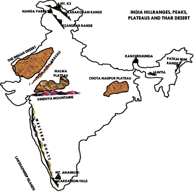
i) Mountain and hill ranges - the karakoram, the zaskar, the patkai bum, the jaintia, the vindhya range, the aravali, and the cardamon hills.
ii) Peaks, K2, kanchenjunga, nanga parbat and the animudi
iii) Plateau chotanagapur and Malva.
iv) The Indian Desert, Western ghats, Lakshadweep Islands.
2 Mark Questions
- The sun rises two hours earlier in Arunachal Pradesh as compared to Gujarat in the west. But the clock show the same time. How does this happens?
A.- Arunachal Pradesh is in the eastern most part of |India. Gujarat is to the western most part of India. There is a maximum distance between these two places in 20,000km.
- The time difference between Arunachal Pradesh and Gujarat is 2 hrs.
- The sun rises two hours earlier in Arunachal Pradesh as compared to Gujarat in the west this causes a time loss of two hours from Gujarat to Arunachal Pradesh.
-
To remove the time difference, the time at 821/2° East longitude to taken as Indian standard time. Because of this reason all the clocks show the same time.
- If the Himalayas would have not been in its present position how would be the climatic conditions of Indian sub- continent?
A.- The formation of the Himalayas influences the climate in various ways.
- The Himalayas act as barriers potecting the great plains of India from the cold winds of central asia during severe winter.
- The Himalayas are reason for summer rains and monsoon type climate in regions that are beyond the western ghats of India.
-
In its absence this region would have remained drier. India would have been tropical desert.
- The Himalayas do not extend into which of the following states? Madhya Pradesh, Uttar pradesh, Skkim, Haryana, Punjab, Uttarakhand?
A. The Himalayas do not extend into the following states.- Madhya Pradesh
- Uttar Pradesh
- Haryana
- Punjab
- Identify the following
- The islands formed due to volcanic eruption Narcondam and Barren Islands
- The countries constituting India sub continent Bangladesh, Srilanka, Maldives, Nepal, Bhutan, Pakistan, Tibet (China) Mayanmar.
- The states through which the tropic of cancer passes Gujarat, Rajasthan, Madhya Pradesh, Chattisgarth, Jarkhand, West Bengal, Tripura and Mizoram.
- The northern most latitude in degrees?
The northern most latitude in degrees 37.6 north latitude. - The southern most latitude of the Indian mainland in degrees
The southern most latitude of the Indian mainland in degrees 8.4 north - The eastern and the western most longitudes in degrees
Eastern most longitude : 97.25 east
Western most longitude : 68.7 East - The place situated on the three seas kanyakumari is the place which is situated on the three seas.
- The strait separating Srilanka from India?
The palk straight seperates Srilanka from India. - The union Teritories of India
i) Andaman and Nicobar Islands
ii) Chandigarh
iii) Dadra and Nagar Haveli
iv) Lakshadweep
v) Nct of Delhi and
vi) Puducherry


More Articles


Most Read


