

Sakshi Education
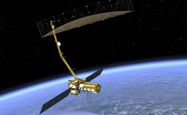
- NASA-ISRO SAR (NISAR) is a Low Earth Orbit (LEO) observatory being jointly developed by NASA and ISRO. NISAR will map the entire globe in 12 days and provide spatially and temporally consistent data for understanding changes in Earth’s ecosystems, ice mass, vegetation biomass, sea level rise, ground water and natural hazards including earthquakes, tsunamis, volcanoes and landslides. NISAR. It carries L and S dual band Synthetic Aperture Radar (SAR), which operates with Sweep SAR technique to achieve large swath with high resolution data. The SAR payloads mounted on Integrated Radar Instrument Structure (IRIS) and the spacecraft bus are together called an observatory. Jet Propulsion Laboratories and ISRO are realizing the observatory which shall not only meet the respective national needs but also will feed the science community with data encouraging studies related to surface deformation measurements through repeat-pass InSAR technique.
- This flagship partnership would have major contributions from both agencies. NASA is responsible for providing the L-Band SAR payload system in which the ISRO supplied S-Band SAR payload and both these SAR systems will make use of a large size (about 12m diameter) common unfurl able reflector antenna . In addition, NASA would provide engineering payloads for the mission, including a Payload Data Subsystem, High-rate Science Downlink System, GPS receivers and a Solid State Recorder.
- This would be the first dual frequency radar imaging mission in L-Band & S-Band using an advanced Sweep SAR technique to provide L & S band space-borne SAR data with high repeat cycle, high resolution, and larger swath, with capability of full-polar metric and interferometric modes of operation. It will provide a means of disentangling and clarifying spatially and temporally complex phenomena, ranging from ecosystem disturbances, to ice sheet collapse and natural hazards including earthquakes, tsunamis, volcanoes, and landslide This is expected to provide impetus to the fast maturing microwave remote sensing applications in geosciences. The precision interferometric orbits of the mission will enable in mapping few millimetres of deformations in the land surface. The selection of lower frequency bands will cater to the need for better characterization of vegetation, which is vital for global carbon stock estimation and monitoring of carbon fluxes from vegetation. Similarly, the selection of L- and S-band frequencies will enable characterizing targets beneath tree canopy and sub-surface features due to differential penetration of the signals in two frequency NISAR studying concepts for a Synthetic Aperture Radar mission is to determine Earth change in three disciplines: ecosystems (vegetation and the carbon cycle), deformation (solid Earth studies), and cryosphere sciences (primarily as related to climatic drivers and effects on sea level NISAR will acquire data over the Indian Coasts and monitor annual changes in the bathymetry along the deltaic regions. The shoreline and the erosion accretion also will be monitored. The NISAR mission will observe sea ice characteristics over the seas surrounding India’s Antarctic polar stations, can be used to detect the marine oil spill and disseminate the spill location during accidental oil seepage for preventive measures.
- The NISAR observatory carries a 12m wide deployable mesh reflector mounted onto a deployable 9m boom developed by JPL which shall be used by both-JPL-NASA developed L-Band SAR payload system and ISRO developed S-Band SAR payload. The IRIS hosts the S-SAR and L-SAR tiles along with their electronics and data handling systems. The spacecraft incorporates all the attitude and orbit control elements, power systems, thermal management system. JPL also will provide the LSAR Data Handling system, High-rate Science data Downlink System, GPS receivers and a Solid State Recorder. ISRO is responsible for providing the SSAR data handling system, High rate downlink system, spacecraft bus systems, the GSLV launch system and Mission Operations Related Services. A perfect blend of two cultures and a creation by two sets of craftsmen is what NISAR is.
>> Download Current Affairs PDFs Here
Download Sakshi Education Mobile APP

Published date : 27 May 2023 05:18PM