

Amid global warming, rapid development, rising population, and increasing migration to urban areas, water managers in India must handle a growing water crisis. As per a study, “Reassessment of Water Availability in India using Space Inputs” in 2019 by the Central Water Commission, Government of India, the per capita water availability is reducing every decade. It was 1545 cubic meters in 2011, reduced to around 1400 cubic meters in 2021, and is slated to reduce further. With global warming and the increase in population, the demand for irrigation to maintain or increase the agricultural output is also rising. In addition, global warming and climate change have increased the frequency and intensity of extreme rainfall in India, which further reduces our ability to store sufficient water using current water resources infrastructure to meet the rising demand.
As a solution to this problem, the government has planned river-linking projects where major river basins of the country will be linked using a network of around 15000 km of canals and around 3000 reservoirs that would transport 174 billion cubic meters of water each year. These projects present a state-of-the-art engineering solution to India’s heaping water crisis. They target an increase in the irrigated area across the country by 30 million hectares, of which around 20 million hectares belong to regions fed by Himalayan rivers while around 10 million hectares belong to regions fed by peninsular rivers. In addition, these projects will generate hydropower of around 34 million kilowatts, along with benefits like flood control, drought mitigation, and navigation. As these projects are implemented, water resource management in India will shift towards an integrated multi-reservoir operation to keep the maximum possible water on land, which earlier used to go into the Arabian Sea or the Bay of Bengal.
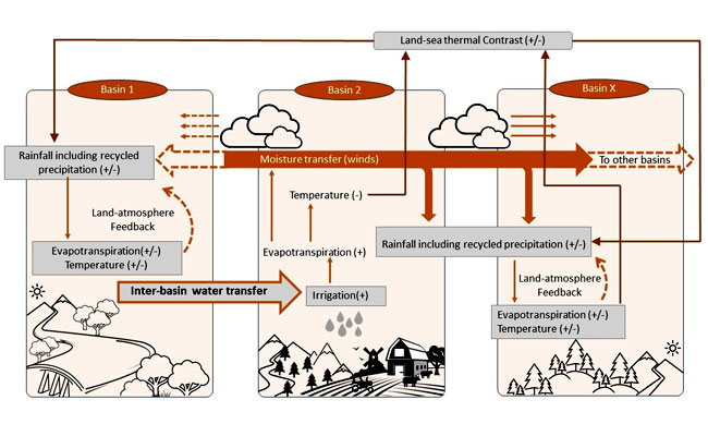
However, the planning of such projects considers river basins as independent hydrological units with no existing atmospheric connections. It is well known that irrigation feeds moisture to the Indian monsoon in its later stages in August and September through land-atmosphere feedback. Evapotranspiration from land contributes moisture to the air, which then gets precipitated again as rainfall called ‘recycled precipitation’ (water gets recycled on land instead of from the oceans). Recycled precipitation contributes to around 25% of monsoon rainfall in September. This means that the river basins might already be linked to each other through the atmospheric pathways, which raises the following question: how would large-scale irrigation from inter-basin water transfer perturb this existing system? And what does it mean for the Indian monsoon, which is known to be heavily dependent on land-atmosphere feedback?
The researchers explored these questions by analysing major river basins of the country (Ganga, Godavari, Mahanadi, Krishna, Cauvery, and Narmada-Tapi). They found that river basins in India are already linked by land-atmosphere feedback. They used multiple causal discovery methods to show that these river basins are linked using within-basin (land → atmosphere) and cross-basin (atmosphere → atmosphere) links. As water evaporates or rains within a basin, it links land to the atmosphere. Across the basins, as the winds transport water, it forms atmospheric links. The Researchers found that large-scale irrigation from river interlinking can change the spatial patterns of the Indian summer monsoon. They demonstrate, using a regional climate model coupled to a land process model developed at the IIT Bombay earlier, they simulated the irrigation targets of these projects. The simulations indicate up to 12% reduction in September rainfall in some arid regions of the country, while the increase of up to 10% in other parts. The results also show that these feedbacks can exacerbate or act against the climate impacts of natural climate drivers such as the ENSO. Such changes in spatial patterns of monsoons due to the feedback also need to be incorporated into the proposed planning of reservoir operation and canal water transfer to gain maximum benefits from the interlinking projects.
This work demonstrates that altering the terrestrial water cycle can impact atmospheric processes. Hence, while planning for large-scale hydrological projects like river interlinking, there is an urgent need to include rigorous model-guided evaluation of hydro-meteorological consequences. While there is no denying that these projects have the potential to mitigate the water crisis of our agricultural-dominant country, such projects need a holistic evaluation and subsequent planning incorporating the land-atmosphere feedback, ecological impacts, groundwater interactions, oceanic changes, etc., for efficient and sustainable water resources management.
The work is led by Prof. Subimal Ghosh of IIT Bombay, with Prof. Karumuri Ashok of the CEOAS, UoH providing guidance in factoring the roles of interannual climate drivers such as the ENSO, among other things. The work is partially financially supported by the University of Hyderabad Institution of Excellence (IoE) grant.


More Articles