

Sakshi Education
By Srirangam Sriram, Sriram's IAS, New Delhi.
Recent News: 
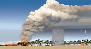
Pyro cumulonimbus is the fire-breathing dragon of clouds. A pyro cumulonimbus storm combines smoke and fire with the features of a violent thunderstorm. Pollutants from these storms are funnelled into the stratosphere. A cumulonimbus without the "pyre" part is imposing enough -- a massive, anvil-shaped tower of power reaching five miles (8 km) high, hurling thunderbolts, wind and rain.
Add smoke and fire to the mix and you have pyro cumulonimbus, an explosive storm cloud actually created by the smoke and heat from the fire, and which can ravage tens of thousands of acres. And in the process, "pyroCb" storms funnel their smoke like a chimney into Earth's stratosphere, with lingering ill effects like Ozone layer destruction.
Global Impact
They also suggest pyroCbs happen more often than thought and say they're responsible for a huge volume of pollutants trapped in the upper atmosphere.
Recent News:
- Amazon Rain Forest fires created these clouds which further added in the spread of fires.
- Australian Bush fires also created destructive Pyro cumulonimbus Cloud
Published date : 10 Nov 2020 11:46AM