

Sakshi Education
- Presena Glacier Covered with Tarps
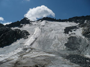 Giant sheets of tarpaulin (tarps) are being used to cover Presena glacier in northern Italy to slow melting caused by global warming.
It is a part of the conservation project (undertaken by Italian firm Carosello-Tonale) which was launched in 2008 — at that point only 30,000 sq metres of the glacier was covered.
Key Points
Covering of the Glacier:
Tarpaulin sheets (tarps) are being laid over 1,00,000 sq metres of the Presena glacier.
Rs. 34,091 tarpaulin sheets will be sewn together once they are stretched over the snow to keep warm air out. Bags of sand are used to weigh them down.
This six-week process is repeated every year once the ski season is over and summer begins in full force.
A ski season is a period when skiing, snowboarding and other alpine sports are viable in an alpine resort.
The process of removing the protective tarps will begin in September, and will take six months.
Tarpaulin Sheets:
Tarpaulin is a large sheet of strong, flexible and water-resistant material, often coated and made of plastics such as polyethylene.
Geotextile tarpaulins reflect sunlight, maintain a temperature lower than the external one, and thus preserve as much snow as possible.
There are similar glacier cover systems on a few Austrian glaciers, but the surface covered by the tarpaulins is much smaller.
Concern:
Since 1993, the Presena glacier has lost more than one third of its volume.
The area is continuously shrinking, so the efforts are made towards covering the area as much as possible.
- Gee’s Golden Langur
Primatologists have observed that the threat of electrocution and inbreeding is increasing among the Gee’s Golden Langur.
Key Points
Scientific Name: Trachypithecusgeei
About: Golden langurs can be most easily recognized by the color of their fur, after which they are named.
It has been noted that their fur changes colors according to the seasons as well as geography (region they live in).
The color of the young also differs from adults in that they are almost pure white.
They are highly dependent on trees, living in the upper canopy of forests. They are also known as leaf monkeys.
Habitat:
It is endemic to western Assam, India, and southern Bhutan.
Their habitat is restricted to the region surrounded by four geographical landmarks: the foothills of Bhutan (North), Manas river (East), Sankosh river (West), and Brahmaputra river (South).
Threats:
Restricted Habitat: As mentioned above, their habitat is restricted by natural boundaries further increasing the threat of extinction.
Habitat Fragmentation: Their habitat in Assam has fragmented drastically especially after a thrust on rural electrification and massive deforestation.
Inbreeding: Obstructions such as wires, and gaps in the forest due to felling, have increased the threat of inbreeding among golden langurs.
Conservation Efforts/Status:
The Central Zoo Authority, New Delhi entrusted the state zoo with the project for the conservation breeding of golden langur in Assam in 2011.
In 2019, Bhutan recorded a drop of 62% in the population of golden langurs over the 2009 census.
The recorded estimation in Assam in 2009 was 5,140. This year’s census could not be completed due to the Covid-19 lockdown.
Protection Status:
IUCN List of Threatened Species: Endangered
Convention on International Trade in Endangered Species of Wild Fauna and Flora (CITES): Appendix I
Wildlife Protection Act, 1972: Schedule I
- Smuggling of Exotic Macaws
Recently, the Directorate of Revenue Intelligence (DRI) has busted a wildlife syndicate (smuggling group) which was involved in smuggling of exotic macaws from Bangladesh.
The joint operation was carried out in coordination with the Wildlife Crime Control Bureau (WCCB) and the Customs Department at the Kolkata airport.
Key Points
The Joint Operation:
The cargo containing 22 exotic birds which had been smuggled in through the Bongaon area of Indo-Bangla border, were seized at Kolkata airport.
The birds were identified as hyacinth macaw, pesquet’s parrot, severe macaw and hahn’s macaw.
The seized macaws are protected under the Convention on International Trade in Endangered Species of Wild Fauna and Flora (CITES), with hyacinth macaw being accorded the highest protection.
Provisions Related to Illegal Wildlife Trade:
Illegally imported birds are confiscated under Section 111 of the Customs Act, 1962 which is read with the CITES provisions and the Foreign Trade Policy (Import-Export Policy) of India.
Also, Sections 48 and 49 of the Wildlife Protection Act prohibit trade or commerce in wild animals, animal articles or trophies.
Concerns:
The possibility of spread of zoonotic diseases on account of smuggling in such exotic species is increasingly becoming a global concern against the backdrop of Covid-19.
Illegal wildlife trade was ranked the fourth largest transnational organised crime globally, after the smuggling of narcotics, counterfeit goods and human trafficking.
West Bengal and northeast India are vulnerable to cross-border wildlife smuggling because of their proximity to the Bangladesh and Myanmar borders, and to Thailand.
Over the recent years, the DRI has seized a range of endangered species, including black-and-white ruffed lemur, hoolock gibbons, palm civets and Indian star tortoise etc.
Another major concern has been the smuggling of elephant tusks and ivory products.
Many international organisations involved in wildlife crime use the Indo-Bangladesh Border for various other illegal activities, such as smuggling of drugs, commercial goods, and even gun-running, apart from illegal movement of foreign currency.
- Mt. Merapi of Indonesia
Mount Merapi, an active volcano in Indonesia, erupted twice on 21st June, 2020.
Key Points
Mt Merapi:
Merapi (Mountain of Fire) is the most active of Indonesia’s 130 active volcanoes.
It rises to 2,911 metres and has steep slopes with dense vegetation on its lower sides.
It is located near the centre of the island of Java and Indonesia’s cultural capital, Yogyakarta.
Mt Merapi’s last significant eruption was in 2010. At that time, more than 300 people were killed and some 2,80,000 residents were forced to evacuate the surrounding areas.
Volcanoes in Indonesia:
Indonesia is located on the Pacific Ring of Fire.
The Ring of Fire, also referred to as the Circum-Pacific Belt, is a path along the Pacific Ocean characterized by active volcanoes and frequent earthquakes.
Its length is approximately 40,000 kilometers. It traces boundaries between several tectonic plates—including the Pacific, Cocos, Indian-Australian, Nazca, North American, and Philippine Plates.
75% of Earth’s volcanoes i.e. more than 450 volcanoes are located along the Ring of Fire. 90% of Earth’s earthquakes occur along its path, including the planet’s most violent and dramatic seismic events.
The abundance of volcanoes and earthquakes along the Ring of Fire is caused by the amount of movement of tectonic plates in the area.
Along much of the Ring of Fire, plates overlap at convergent boundaries called subduction zones. That is, the plate that is underneath is pushed down, or subducted, by the plate above. As rock is subducted, it melts and becomes magma. The abundance of magma so near to Earth’s surface gives rise to conditions ripe for volcanic activity.
A significant exception is the border between the Pacific and North American Plates. This stretch of the Ring of Fire is a transform boundary, where plates move sideways past one another. This type of boundary generates a large number of earthquakes as tension in Earth’s crust builds up and is released.
- Fishing Cats in Bhitarkanika National Park
The Odisha Government has started a two-year conservation project for Fishing Cats in Bhitarkanika National Park.
Like several other rare species, little is known about fishing cats in the wild.
Scientific Name: Prionailurusviverrinus.
KEYPOINTS:
Description:
It is twice the size of a house cat.
The fishing cat is nocturnal (active at night) and apart from fish also preys on frogs, crustaceans, snakes, birds, and scavenges on carcasses of larger animals.
The species breed all year round.
They spend most of their lives in areas of dense vegetation close to water bodies and are excellent swimmers.
Habitat: In India, fishing cats are mainly found in the mangrove forests of the Sundarbans, on the foothills of the Himalayas along the Ganga and Brahmaputra river valleys and in the Western Ghats.
Threats:
Habitat Destruction: A major threat for fishing cats is the destruction of wetlands, their preferred habitat.
Shrimp Farming: Shrimp farming is another growing threat to mangrove habitats of the Fishing Cat.
Hunting: This unique cat also faces threats from hunting for meat and skin.
Ritual Practices: Tribal hunters indulge in ritual hunting practices throughout the year.
Poaching: It is also occasionally poached for its skin.
Poisoning: Indiscriminate trapping, snaring and poisoning.
Protection Status:
IUCN Red List: Vulnerable. Despite multiple threats, the Fishing Cat was recently downlisted to “Vulnerable” from “Endangered” in the IUCN Red List species assessment.
CITES: Appendix II
Indian Wildlife Protection Act, 1972: Schedule I
Conservation Efforts:
The Fishing Cat Project, launched in 2010 started raising awareness about the Cat in West Bengal.
In 2012, the West Bengal government officially declared the Fishing Cat as the State Animal and the Calcutta Zoo has two big enclosures dedicated to them.
In Odisha, many NGOs and wildlife conservation Societies are involved in Fishing Cat research and conservation work.
- Money Laundering and the Illegal Wildlife Trade
Recently, the Financial Action Task Force (FATF) has released the first global report on the Illegal Wildlife Trade (IWT) namely, “Money Laundering and the Illegal Wildlife Trade”.
The report comes amid increasing international concern that the crime could lead to more zoonotic diseases in the future.
The report has also described IWT as a “global threat”, which also has links with other organised crimes like modern slavery, drug trafficking and arms trade.
Key Points
Transnational Organised Crime:
The parties involved in the IWT are usually engaged in other major transnational organised crime that fuels corruption, threatens biodiversity, and can have significant public health impacts.
The illegal trade is estimated to generate revenues of up to $23 billion a year.
According to the 2016 UN World Wildlife Crime report, criminals are illegally trading products derived from over 7,000 species of wild animals and plants across the world.
Origin and Route of IWT:
Usually, the countries that are rich in biodiversity and/or where there may be weaker law enforcement oversight and criminal justice are treated as source countries for IWT.
Similarly, most parties involved in such crime transit the wildlife through other countries to blur the exact end destination.
Transit countries typically include trade and transport hubs or countries with higher levels of corruption. The laundering of the proceeds occurs across source, transit and destination countries.
Methods Used for IWT:
It has been observed that the criminals are relying on “established” methods to launder proceeds from IWT, including mobile or social media-based payments, third party payments and the placement and layering of funds through the formal financial sector.
The accounts of innocent victims are also used for high-value payments to avoid and evade detection.
IWT also uses shell and front companies to conceal payments and launder their money.
Shell company is an inactive company used as a vehicle for various financial manoeuvres or kept dormant for future use in some other capacity.
A front organization is any entity set up by and controlled by another organization, such as, organized crime groups, banned organizations, religious or political groups, advocacy groups, or corporations.
Also, legitimate pet stores and private zoos, farms or parks are often used to facilitate the illicit pet trade in many countries (such as Asia and the Americas) and are used to justify trading, breeding, or otherwise exploit protected wildlife.
Additionally, the role of online marketplaces and mobile, social media-based payments and darknets have facilitated the fast and movement of illegally traded animals.
Link with Zoonotic Diseases:
The spread of zoonotic diseases underlines the importance of ensuring that wildlife is traded in a legal, safe and sustainable manner and that countries remove the profitability of illegal markets.
The exact connection between the trading of pangolins and its scales to the Covid-19 outbreak is yet to be established but it has been noted that the price of pangolins has increased between 100% to 600% mark-up.
Further, India has also been a source country for illegal pangolin trading.
Challenges with IWT
The lack of the required knowledge, legislative basis and resources to assess and combat the threat posed by the funds generated through the illegal trade is one of the major issues with IWT. This limited focus on the financial side of IWT has largely prevented jurisdictions from being able to identify and sanction IWT networks.
IWT makes other industries more vulnerable to misuse which includes traditional medicine, décor and jewellery and fashion.
Recommendations
The countries should consider implementing the good practices which include providing all relevant agencies with the necessary mandate and tools; and cooperating with other countries, international bodies and the private sector.
The legislative changes are necessary to increase the applicability of anti-money laundering laws to the illegal wildlife trade-linked offences.
India amended the Prevention of Money Laundering Act in 2012 removing a value threshold — of ?30 lakh and above — that was earlier applicable to the wildlife trade predicates.
It has suggested treating IWT as money laundering offences since the proceeds enter the global market through money laundering and also money laundering offences carry more severe penalties in many countries.
- Increased Ozone Pollution
Recently, the Centre for Science and Environment (CSE) has observed an increase in ozone (a harmful pollutant) levels in the several cities of the country.
The analysis is based on Central Pollution Control Board (CPCB) data from 22 cities in 15 States.
It has also observed that the particulate matter and nitrous oxide levels fell during the lockdown to control Covid-19 outbreak.
Key Points
Ozone Gas:
The ‘good’ ozone present in the earth’s ozone layer protects human beings from harmful Ultraviolet (UV) radiation whereas the ground level ozone is highly reactive and can have adverse impacts on human health.
Even short-term exposure of an hour is dangerous for those with respiratory conditions and asthma. Thus, an 8-hour average is considered for ozone instead of the 24-hour average for other pollutants.
Ozone is not directly emitted by any source but is formed by photochemical reactions between oxides of nitrogen (NOx), other volatile organic compounds (VOCs) and gases in the air under the influence of sunlight and heat.
Ozone pollution is thus also a clear indicator of vehicular pollution, which results in higher concentration of NOx.
Concept of Summer Pollution:
The ozone is primarily a “sunny weather problem” in India as the presence of sunlight has a direct impact on formation of ground level ozone.?
Heat acts as a catalyst, facilitating photochemical reactions. Hence, higher concentrations of ozone are seen during the summer months.
Additionally, the intense heat waves are one of the factors responsible for increased ozone levels in the country.
Usually, the ozone levels tend to spike when winter conditions subside, and its presence is felt most during the day. At night, ozone levels tend to deplete, before spiking again during the afternoon, when sunlight is available.
Thus, the characteristics of summer pollution include high winds, intermittent rains, thunderstorms, high temperature and heat waves.
Particulate Pollution:
It has been observed that the particulate pollution has been dropped dramatically during the lockdown.
Also, an average PM 2.5 levels during the lockdown for all cities were found to be lower than the average for the same period in 2019.
However, with lockdown relaxed, pollution started to increase. As soon as lockdown 4.0 came in with more relaxation and traffic returned on roads, the average NO2 levels increased rapidly from the cleanest lockdown phase.
- Pollinator Week (22nd June to 28th June)
Pollinator Week is celebrated from 22nd June to 28th June every year.
It was initiated by the non-profit Pollinator Partnership and the USA’ Senate in 2007.
Key Points
According to the Food and Agriculture Organization (FAO), bees being the dominant pollinators, have around 25,000-30,000 species.
More than 180,000 plant species, including 1,200 crop varieties, across the world, depend on pollinators to reproduce.
Declining Numbers:
Around 40% of invertebrate pollinator species, particularly bees and butterflies, face extinction across the world.
In India, wild honeybees of the genus Apis, including the Asian bee and the little bee, have declined steadily for the past 30 years.
Around 16.5% of vertebrate pollinators are threatened with extinction.
Of these, 45 species of bats, 36 species of non-flying mammals, 26 species of hummingbirds, seven species of sunbirds and 70 species of passerine birds face extinction.
Reasons for the Decline: Most of them are the result of an increase in human activities:
Land-use change and fragmentation.
Changes in agricultural practices including the use of chemical pesticides, fungicides and insecticides.
Change in the cropping pattern and crops like the cultivation of Genetically Modified Organisms (GMOs) and mono-cropping.
High environmental pollution from nitrogen and heavy metals.
Growth of invasive alien species.
Higher temperatures associated with climate change.
- NCPOR study of Coccolithophores
Recently, the National Centre for Polar and Ocean Research (NCPOR) has carried out the study of Coccolithophores (microscopic ancient marine algae) and found that there is a decrease in the concentration of oceanic calcium carbonate (CaCO3) in the southern Indian ocean.
Key Points
Coccolithophores are single-celled algae living in the upper layers of the world’s oceans.
They calcify marine phytoplankton that produce up to 40% of open ocean calcium carbonate and are responsible for 20% of the global net marine primary productivity.
They build exoskeletons from individual CaCO3 plates consisting of chalk and seashells.
Though carbon dioxide (CO2) is produced during the formation of these plates, coccolithophores help in removing it from the atmosphere and ocean by consuming it during photosynthesis.
At equilibrium, they absorb more CO2 than they produce, which is beneficial for the ocean ecosystem.
Abundance and diversity enrichment of coccolithophores in the southern Indian Ocean is highly dependent on time and influenced by various environmental factors such as silicate concentrations, calcium carbonate concentration, diatom abundance, light intensity and availability of macro and possibly micronutrient concentrations (marine pollution).
Diatoms are single-celled algae which occur after sea ice breakdown with climate change and ocean acidification.
Diatoms increase the silicate concentration in the waters and which in turn decreases CaCO3 and reduces coccolithophores diversity.
It will affect the growth and skeleton structure of coccolithophores, with potential significance for the world ocean ecosystem.
The study points to climate change as a major reason for the altered coccolithophore calcification rate which is important for bringing positive changes in the marine ecosystem and the global carbon cycle.
- NCPOR warns about the decline in the Arctic sea ice
The National Centre of Polar and Ocean Research (NCPOR) has warned about the decline in the Arctic sea ice.
The dramatic decline in the Arctic sea ice is due to global warming. The loss of sea ice led to a localized increase in evaporation, air humidity, cloud cover, and rainfall.
Highlights:
It is well known that Arctic sea ice is a sensitive indicator of climate change and has strong retaliatory effects on other components of the climate system.
NCPOR observed that the largest decline in Arctic sea ice in the past 41 years happened in July 2019.
It stated that, in the last 40 years (1979-2018), the sea ice has been declining at a rate of -4.7% per decade, while its rate was found to be -13% in July 2019.
It warned that, if this trend continues, there would be no ice left in the Arctic sea by 2050, which would be dangerous for humanity and the entire environment.
The study also stated that the decline of the Arctic sea ice area and the increase in the duration of summer and autumn seasons have affected the local climate & weather over the Arctic Ocean and its marginal seas.
The report also highlighted that the loss of sea-ice at this rate will have a catastrophic impact due to rising global air temperature and slowing down of global ocean water circulation.
- NGT gives Kerala 1 month to report on forest fire prevention steps
 Directions are given by the Southern Bench of the National Green Tribunal.
Background:
Forest is part of the concurrent list of the seventh schedule of the Indian constitution.
Area covering 93,273 hectares was affected by forest fires in 2019.
National Action Plan on Forest Fire:
Launched in 2018, the plan intends to reduce the vulnerability of forests against fire hazards.
It aims to minimize forest fires by informing, enabling and empowering forest fringe communities and incentivizing them to work with the state forest departments.
It aims to enhance the capabilities of forest personnel and institutions in fighting fires and swift recovery subsequent to fire incidents.
Details:
The Southern Bench of the National Green Tribunal has given one month to the Kerala Forest Department for submitting its report on the steps taken to prevent forest fires and implement the National Action Plan on Forest Fire in the State.
- Malabar Gliding Frog
Recently, a rare amphibian i.e. Malabar Gliding Frog (Rhacophorus malabaricus) was spotted in Pullad, Kerala.
The amphibian is endemic to the rainforest of western ghats.
Endemic species are those plants and animals that exist only in one geographical region.
Key Points
Characteristics:
It is a green frog with slender body, webbed feet, unusual body positions and very well camouflaged.
Camouflage, also called cryptic coloration, is a defense mechanism or tactic that organisms use to disguise their appearance, usually to blend in with their surroundings.
The fingers and toes are like sticks to attach and walk through tree branches.
It has a high gliding ability, with the long skin between the fingers which helps to cover 10 to 12 feet in one leap.
It has a body length of 10 cm, making it one of the largest mossy frogs.
Mossy Frogs: These frogs have the skin which is green in colour and resembles moss growing on the rock.
The breeding period is during the monsoon and usually, the females choose to spawn on the lush green leaves overhanging a waterbody.
As their body is so soft, they can live only in moist forests with streams.
Foam Nests:
They built foam nests above small pools of water, into which the tadpoles drop after hatching.
Behaviour like cannibalism has been found among tadpoles.
Protection Status:
In the International Union for Conservation of Nature (IUCN) Red List, it is placed in the Least Concern category.
Concern: The Malabar gliding frog population is declining due to deforestation, climate change, developmental activities, and toxic chemicals.
- Olms in Postojna Cave of Slovenia
Recently, three Olms have been put on display in Slovenia’s Postojna Cave, where they hatched in 2016 in a rare successful breeding.
Key Points
Description:
The Olms are eyeless (skin covered eyes) pink salamanders also known as the "baby dragon" and "human fish" for its pale skin-like colour.
They feed on detritus and endemic cave vertebrates and hide in crevices or bottom sediment when disturbed. They can survive without food for up to 10 years.
A long-lived species that only matures to a sexual stage after the age of 12-15 years and reproduces very slowly.
It can live a century and breeds only once a decade usually in laboratories throughout Europe or deep in caves away from people.
They have a powerful sensory system of smell, taste, hearing and electro sensitivity.
Threats:
The olm requires clean water and is therefore vulnerable to water pollution.
Consequently, the major threats to the olm are pollution and habitat disturbance from land use changes occurring above the cave systems.
Habitat:
They are found in large subterranean aquatic karst systems formed in limestone and dolomite rocks and may be found in cave entrances.
They are an entirely aquatic species and prefer waters ranging from 5-15°C.
Found in Bosnia and Herzegovina, Croatia, Italy, Slovenia and France.
- Largest Decline in Arctic Sea Ice
The National Centre of Polar and Ocean Research (NCPOR) has observed the largest decline in the Arctic Sea ice in the last 41 years.
The decline in the Arctic Sea ice is due to global warming — leading to localised increase in evaporation, air humidity, cloud cover and rainfall.
Key Points
Increased Rate of Sea Ice Decline:
In the last 40 years (1979-2018), the sea ice has been declining at 4.7% per decade, while the current declining rate was found to be 13% in July 2019.
Thus, it has been noted that the volume of ice formation during winters is unable to keep pace with the volume of ice loss during summers.
Additionally, it has been predicted that if this trend continues, there would be no ice left in the Arctic Sea by 2050.
Impacts:
The decrease of the Arctic Sea ice area and the increase in the duration of summer and autumn seasons affected the local weather and climate over the Arctic Ocean and its marginal seas.
Being a sensitive indicator of climate change, the loss of ice cover in the Arctic Sea may affect other components of the climate system such as reduction of heat, water vapour, and other material exchange between the atmosphere and the sea.
The northern hemisphere experienced record high-temperature rise, especially during the spring and summer months.
- Researchers discovered new fish species discovered in Arunachal Pradesh
A new species of fish has been discovered in the state of Arunachal Pradesh. It was discovered by Dr Keshav Kumar Jha, Associate Professor & Head, Department of Zoology, Jawaharlal Nehru College, Pasighat.
Schizothorax sikusirumensis:
The new species of the fish is named as Schizothorax sikusirumensis. It is from the genus Schizothorax. The name of the new fish species "Schizothorax sikusirumensis" was derived from the name of the rivers where it was found.
The fish species were collected from the junction of River Siku and Sirum. The new fish species inhabit the waterlogged area of torrential river drainage.
- Assessment of Climate Change over the Indian Region: MoES
Recently, the first Assessment of Climate Change over the Indian Region has been published by the Ministry of Earth Sciences (MoES).
It is India’s first-ever national forecast on the impact of global warming on the subcontinent in the coming century.
These projections, based on a climate forecasting model developed at the Indian Institute of Tropical Meteorology (IITM), Pune, will be part of the next report of the Intergovernmental Panel on Climate Change (IPCC), expected to be ready in 2022.
This is a significant step for climate science and policy in India because existing projections are put in the context of historical trends in land and ocean temperatures, monsoon rainfall, floods, droughts and Himalayan warming and glacier loss.
Key Points
Temperature:
In a worst-case scenario, average surface air temperatures over India could rise by up to 4.4°C by the end of the century as compared to the period between 1976 and 2005.
The worst-case scenario is defined by the Representative Concentration Pathway (RCP) 8.5 that calculates a radiative forcing of 8.5 watt per square metre due to the rising greenhouse gas (GHG) emissions in the atmosphere.
Radiative forcing or climate forcing is the difference between sunlight energy absorbed by the Earth (including its atmosphere) and the energy that it radiates back into space.
Under an intermediate scenario of RCP 4.5, the country’s average temperature could rise by up to 2.4°C.
The rise in temperatures will be even more pronounced in the Hindu Kush-Himalayan region where the average could reach 5.2°C.
The region is already highly vulnerable to climate-related variability in temperatures, rainfall and snowfall.
By 2100, the frequency of warm days and warm nights might also increase by 55% and 70% respectively, as compared to the period 1976-2005 under the RCP 8.5 scenario.
The incidences of heat waves over the country could also increase by three to four times. Their duration of occurrence might also increase which was already witnessed by the country in 2019.
Between 1900 and 2018, the average temperatures of India rose by 0.7°C.
This rise in temperatures has been largely attributed to global warming due to GHG emissions and land use and land cover changes.
However, it has also been slightly reduced by the rising aerosol emissions in the atmosphere that have an overall cooling characteristic.
The latest global climate change assessments indicate a rise in worldwide average surface air temperatures by 5°C by the end of the century if human activities keep emitting GHGs at the current rate.
The global average temperature in the last century has gone up by 1.1°C, according to the latest estimates by the IPCC.
Even if the Nationally Determined Contributions (NDCs) declared by countries under the Paris Agreement 2015 are met, the global average temperature could rise by around 3°C, which could be disastrous.
- Land Use Changes
According to the United Nations Convention to Combat Desertification (UNCCD), the land use change, which prepares the ground for zoonoses like Covid-19, should be reversed.
Land use change promotes zoonoses like Covid-19 as the interaction and physical distance between animals and humans get closer.
Key Points
Land Use Change:
Land use change is a process which transforms the natural landscape by direct human-induced land use such as settlements, commercial and economic uses and forestry activities.
It impacts the overall environment in terms of greenhouse gas emission, land degradation and climate change.
Data Analysis:
Land use change can be a factor in CO2 (carbon dioxide) atmospheric concentration and is thus a contributor to global climate change.
It represents almost 25% of total global emissions.
According to the Intergovernmental Platform on Biodiversity and Ecosystem Services (IPBES), over 70% of all natural, ice-free land in the world is affected by human use.
This could further rise to 90% by 2050.
The land degradation affects 3.2 billion people worldwide.
Ecosystem services e.g. forest, agriculture, grassland tourism etc. worth $10.6 trillion are lost due to land degradation annually.
According to the Food and Agriculture Organization of the United Nations, by 2050, over 500 million hectare area of new agricultural land will be needed to meet the global food demand.
Possible Reasons:
Population Growth: Fast population growth and the consequent high pressure on resources have an adverse effect on the existing natural resources of the land area.
Encroachment of Land: Substantial increase in demand for food has resulted in an expansion of croplands by encroaching on uncultivated areas including forest, shrub and wetlands.
According to the Intergovernmental Panel on Climate Change (IPCC) report on climate change and land, agricultural land for food, animal feed and fibre is behind the land use change.
Use of Forest Resource: Continuous and exhaustive thinning of forestry resources for diverse uses, particularly for construction, firewood and agricultural tools led to the degradation of forest cultivated land.
Grazing at Cultivated Land: Farmers often abandon and leave the cultivated land for grazing purposes due to the declining of its soil fertility status.
Destruction of Wetlands: The conversion of the wetland to the cultivated and settlement land leads to the destruction of wetlands.
- Forest Fires
Recently, the National Green Tribunal has directed the Kerala Forest Department to submit its report in one month, on the steps taken to prevent forest fires and implement the National Action Plan on Forest Fire in the State.
Key Points
Forest Fires:
Fire can play a vital role in keeping the forests healthy, recycling nutrients, helping tree species regenerate, removing invasive weeds and pathogens, and maintaining habitat for some wildlife.
As populations and demands on forest resources have grown, the cycle of fire has spun out of balance.
Forest fires have become an issue of global concern. In many countries, wildfires are burning larger areas, and fire seasons are growing longer due to global warming.
Globally, forest fires release billions of tons of CO2 into the atmosphere, while hundreds of thousands of people are believed to die due to illnesses caused by exposure to smoke from forest fires and other landscape fires.
Reasons for Forest Fires:
Thunderstorms are the most likely natural cause for forest fires.
The dry deciduous forests in central and southern India face 5 to 6 months of dry period and are vulnerable to fires.
The reasons are mainly manmade, particularly in cases where people visit forests and leave burning bidis, cigarette stubs or other inflammable materials.
A major reason for forest fires in north-east India is slash-and-burn cultivation, commonly called jhum cultivation.
The north-east has tropical evergreen forests which are not likely to catch fire easily on their own like the dry deciduous forests of central and southern India.
India’s Initiative to Tackle Forest Fire:
National Action Plan on Forest Fires (NAPFF):
It was launched in 2018 to minimise forest fires by informing, enabling and empowering forest fringe communities and incentivising them to work with the State Forest Departments.
The plan also intends to substantially reduce the vulnerability of forests across diverse forest ecosystems in the country against fire hazards.
It also aims to enhance capabilities of forest personnel and institutions in fighting fires and swift recovery subsequent to fire incidents.
Forest Fire Prevention and Management Scheme:
The Forest Fire Prevention and Management Scheme (FPM) is the only centrally funded program specifically dedicated to assist the states in dealing with forest fires.
The FPM replaced the Intensification of Forest Management Scheme (IFMS) in 2017.
Funds allocated under the FPM are according to a center-state cost-sharing formula, with a 90:10 ratio of central to state funding in the Northeast and Western Himalayan regions and a 60:40 ratio for all other states.
It also provides the states to have the flexibility to direct a portion of the National Afforestation Programme (NAP) and Mission for Green India (GIM) funding toward forest fire work.
India has set ambitious policy goals for improving the sustainability of its forests.
As part of the National Mission for Green India under India’s National Action Plan on Climate Change, the government has committed to increase forest and tree cover.
Under its Nationally Determined Contribution, India has committed to bringing 33% of its geographical area under forest cover and to create additional sinks of 2.5 billion to 3 billion tons worth of CO2 stored in its forests by 2030.
- Aerosols Radiative Forcing in Western Trans-Himalayas
 Recently, a study by the Aryabhatta Research Institute of Observational Sciences (ARIES) has found that radiative forcing of aerosols i.e. effect of anthropogenic aerosols is much higher over the high altitudes of western trans-Himalayas.
ARIES, Nainital is an autonomous research institute under the Department of Science and Technology (DST), Ministry of Science and Technology.
The Trans-Himalayas Mountain Region is located to the north of the Great Himalayas which consists of Karakoram, Ladakh, Zaskar and Kailash mountain ranges. It is also called the Tibet Himalayan Region because most of the part of these ranges lies in Tibet.
Key Points
Aerosol Radiative Forcing (ARF) :
The study analysed the variability of aerosol optical, physical and radiative properties from January 2008 to December 2018 and the role of fine and coarse particles in Aerosol Radiative Forcing (ARF) assessment.
The ARF values at top of the atmosphere were mostly low over Hanle and Merak.
ARF is the effect of anthropogenic aerosols on the radiative fluxes at the top of the atmosphere and at the surface and on the absorption of radiation within the atmosphere.
Hanle and Merak, situated in Ladakh are the part of Indian Astronomical Observatory (IAO).
Change in Temperature:
The study shows that monthly-mean atmospheric radiative forcing of aerosols leads to heating rates of 0.04 to 0.13 degree celsius per day.
Further, the temperature over the Ladakh region is increasing 0.3 to 0.4 degree celsius per decade from the last 3 decades.
Aerosol Optical Depth (AOD):
The observations show that the Aerosol Optical Depth (AOD) exhibited a distinct seasonal variation with higher values (0.07) in May and lower (0.03) in winter months.
AOD is a measure of how light is absorbed or reflected by airborne particles as it travels through the atmosphere.
If aerosols are concentrated near the surface, an optical depth of 1 or above indicates very hazy conditions.
An optical depth, or thickness, of less than 0.1 over the entire atmospheric vertical column is considered clean.
Angstrom Exponent (AE):
The lower values of Angstrom Exponent (AE) in spring indicated dominance of coarse-mode dust aerosols.
The Angstrom Exponent is a parameter that describes how the optical thickness of an aerosol typically depends on the wavelength of the light.
Composition of Air:
Pure and polluted dust exhibited fractions between 16% and 23%, with a low frequency of less than 13% of absorbing aerosols, denoting weak influence of anthropogenic aerosols and Black Carbon over the trans-Himalayan sites.
Significance of the Study
The atmospheric aerosols play a key role in the regional/global climate system through scattering and absorption of incoming solar radiation and by modifying the cloud structure.
The transport of light-absorbing carbonaceous aerosols and dust from the polluted Indo-Gangetic Plain and desert areas over the Himalayas constitutes a major climatic issue due to severe impacts on atmospheric warming and glacier retreat.
This heating over the Himalayas facilitates the “elevated-heat pump” that strengthens the temperature gradient between land and ocean and modifies the atmospheric circulation and the monsoon rainfall.
A deep scientific study of aerosol generation, transport, and its properties have important implications in the mitigation of climate change.
The study can help better understand the aerosol optical and microphysical properties and improve the modelling of aerosol effects in view of aerosol-climate implication via modifications in atmospheric warming and changes in the snow/glacier albedo over the trans-Himalayan region.
- Sunderbans Damaged in Cyclone Amphan
Recently, the Chief Minister of West Bengal highlighted that about 28% of the Sunderbans has been damaged by Cyclone Amphan and launched a drive for planting mangroves and trees to mark the World Environment Day (5th June).
Key Points
The Indian Sunderbans, an area south of the Dampier Hodges line, is spread over 9,630 sq km, of which the mangrove forest accounts for 4,263 sq km.
1,200 sq km of that mangrove forest has been destroyed.
Mangroves not only reduce wind speed but break the waves during a storm surge caused by a cyclone.
Trees turned yellow and red after the cyclone mostly due to salinity and trees can only survive if the salinity of the soil comes down.
Dampier Hodges line is an imaginary line, passing through 24 Parganas South and North districts (West Bengal) which indicates the northern-most limits of the estuarine zone affected by tidal fluctuations.
The damage has been much on the Indian side of the Sundarbans and not on the Bangladesh side.
The CM has directed the Forest Department to be prepared to plant 3.5 crore mangroves by 14th July which is celebrated as the World Forest Day.
- Advisory on Importing Live Exotic Animals
Recently, the Ministry of Environment, Forest and Climate Change has issued an advisory to streamline and formalize the process of importing live exotic animals.
Many exotic species of birds, reptiles and amphibians are imported into India for commercial purposes.
Key Points
Exotic Animals:
The term exotic does not have a set definition but it usually refers to a wild animal or one that is more unusual and rare than normal domesticated pets like cats or dogs.
These are those species which are not usually native to an area and are introduced to an area by humans.
The advisory has defined them as those that are mentioned under the Appendices of the Convention on International Trade in Endangered Species of Wild Fauna and Flora (CITES) but not under the Schedules of the Wild Life (Protection) Act, 1972.
The major reason for issuing the advisory is to regulate trade because the issue of zoonotic diseases is linked to wildlife. With this advisory, it will be known how many such exotic animals are there in the country.
- Environmental Performance Index
India secured 168th rank in the 12th edition of the Environment Performance Index (EPI) 2020.
India’s rank was 177th in 2018.
Environmental Performance Index
EPI is a biennial index prepared by Yale University and Columbia University in collaboration with the World Economic Forum.
It offers a scorecard that highlights leaders and laggards in environmental performance and provides practical guidance for countries that aspire to move toward a sustainable future.
This index was first published in 2002 designed to supplement the environmental targets set forth in the United Nations Millennium Development Goals.
Key Points
EPI 2020:
EPI Index 2020 measured the environmental performance of 180 countries.
The index considered 32 indicators of environmental performance and included 10-year trends in environmental performance at the national and global levels.
Denmark topped the index with a score of 82.5.
India’ Performance:
India scored 27.6 out of 100 in the 2020 EPI index and its performance was worse than all South Asian countries, except Afghanistan.
India scored below the regional (South-Asia) average score on all five key parameters on environmental health, including air quality, sanitation and drinking water, heavy metals and waste management.
These findings resonated with the concerns raised by the ‘State of India’s Environment 2020 in Figures’, published by the Centre for Science and Environment.
It has also scored below the regional average on parameters related to biodiversity and ecosystem services too.
India was at second position after Pakistan on ‘climate change’ among the South-Asia countries.
Pakistan’s score (50.6) was the highest under the climate change category.
A ten-year comparison progress report in the index showed that India slipped on climate-related parameters.
The report indicated that black carbon, carbon dioxide emissions and greenhouse emissions per capita increased in ten years.
- Sixth Mass Extinction
Recently, the researchers have observed that the ongoing sixth mass extinction is one of the most serious environmental threats to the existence of civilisation.
Mass extinction refers to a substantial increase in the degree of extinction or when the Earth loses more than three-quarters of its species in a geologically short period of time.
Since life first evolved on the planet, a short geological period of time is defined as less than 2.8 million years.
Key Points
Background:
The five mass extinctions that took place in the last 450 million years have led to the destruction of 70-95% of the species of plants, animals and microorganisms that existed earlier.
All these extinctions were caused due to the catastrophic alterations to the environment, such as massive volcanic eruptions, depletion of oceanic oxygen or collision with an asteroid.
After each of these extinctions, it took millions of years to regain species comparable to those that existed before the event.
Ongoing Sixth Mass Extinction:
It has been observed that the sixth extinction is human-caused and is more immediate than climate destruction. Thus, the ongoing sixth mass extinction is referred to as the anthropocene extinction.
Currently, only an estimated 2% of all of the species that ever lived are alive but the absolute number of species is greater than ever before.
It is described as the most serious environmental problem since the loss of species will be permanent.
The loss of species has been occurring since human ancestors developed agriculture over 11,000 years ago. Since then, the human population has increased from about 1 million to 7.7 billion.
Outcomes of the Study:
The study has described sixth mass extinction as the most serious environmental problem.
The study analysed 29,400 species of terrestrial vertebrates and concluded that over 515 of them are near extinction.
Most of these 515 species are from South America (30%), followed by Oceania (21%), Asia (21%) and Africa (16%) among others.
It has also observed that the disappearance of these populations has been occurring since the 1800s.
Impacts:
The extinction of the species causes tangible impact such as in the form of a loss in crop pollination and water purification.
Further, if a species has a specific function in an ecosystem, the loss can lead to consequences for other species by impacting the food chain.
When the number of individuals in a population or species drops too low, its contributions to ecosystem functions and services become unimportant.
The effects of extinction are expected to worsen the genetic and cultural variability which would change entire ecosystems.
When genetic variability and resilience is reduced, its contribution to human welfare may be lost.
- Assam Gas Leak
Recently, a gas leak has occurred at Baghjan well in Tinsukia district of Assam following a blowout.
The Baghjan well is a purely gas-producing well in Tinsukia district, and is at an aerial distance of 900 metres from the Dibru-Saikhowa National Park.
It has been drilled by Oil India Limited (OIL) since 2006.
Natural gas is a mix of propane, methane, propylene and other gases.
Key Points
Gas Leak:
The gas well at Baghjan was under maintenance, for which it was temporarily shut. The Blowout Preventer (BOP) was also removed.
However, the gas started to ooze out of the well during the maintenance.The reason behind the blowout (a sudden/uncontrolled release of gas/oil) is not clear.
Possible Reasons:
It may have occurred due to lack of attention, poor workmanship, bad maintenance, old age, sabotage to morpho-tectonic factors.
Sometimes, the disturbance of pressure balance in a well may also lead to sudden blowouts.
Steps Taken: The authorities have built a temporary water reservoir through pipelines from the Dangori river nearby the well to control the blowout.
To control a blowout, a huge quantity of water is required so that the gas does not catch fire.
The control of a blowout depends on two things: the size of the reservoir and the pressure at which the gas is flowing out. Many blowouts also automatically collapse on their own.
- Microplastics in Deep Oceans
Recently, researchers have observed that deep sea hotspots of biodiversity are also likely to be microplastic hotspots.
Although microplastics are known to spread on the global seafloor, the processes that control their dispersal and concentration in the deep sea remain largely unknown.
The researchers have studied the spatial distribution and ultimate settling position of the microplastics and its effects on the biodiversity hotspots in the deep oceans.
There are above-ground biodiversity hotspots like the tropical rain forests, alpine tundra, etc. Likewise, there are landforms beneath the sea that provide rich marine diversity which include Coral reefs, Sea mounts, etc.
Key Findings
Role of Thermohaline Circulations:
It has been observed that thermohaline-driven circulations can control the distribution of microplastics by creating hotspots of accumulation, analogous to current’s role in depositing seafloor sediments.
The ocean currents are usually driven by the winds in the upper 100 meters of the ocean’s surface. However, ocean currents also flow thousands of meters below the surface.
The ocean currents may be classified based on their depth as
Surface Currents : The surface currents constitute about 10 % of all the water in the ocean, these waters are the upper 400 m of the ocean.
Deep Ocean Currents: These currents make up the other 90 % of the ocean water. These currents are driven by differences in the water’s density, which is controlled by temperature (thermo) and salinity (haline). This process is known as thermohaline circulation.
In the Earth's polar regions ocean water gets very cold, forming sea ice. As a consequence the surrounding seawater gets saltier, because when sea ice forms, the salt is left behind.
As the seawater gets saltier, its density increases, and it starts to sink. Surface water is pulled in to replace the sinking water, which in turn eventually becomes cold and salty enough to sink. This initiates the deep-ocean currents driving the global conveyor belt.
Vulnerability of Benthos:
Further, these thermohaline currents supply oxygen and nutrients to deep-sea benthos, so deepsea biodiversity hotspots are also likely to be microplastic hotspots.
Benthos is the community of organisms that live on, in, or near the seabed, river, lake, or stream bottom, also known as the benthic zone.
- Athirapally Hydel Electric Project
Recently, the Kerala government has approved the proposed Athirapally Hydro Electric Project (AHEP) on the Chalakudy River in Thrissur district of the state.
There are already five dams for power and one for irrigation and it will be the seventh along the 145 km course of the Chalakudy river.
Key Points
The total installed capacity of AHEP is 163 MW and the project is supposed to make use of the tail end water coming out of the existing Poringalkuthu Hydro Electric Project that is constructed across the Chalakudy river.
AHEP envisages diverting water from the Poringalkuthu project as well as from its own catchment of 26 sq km.
Kerala state government has given a no-objection certificate (NOC) to the Kerala State Electricity Board (KSEB) for a period of seven years and has permitted it to proceed with the project’s implementation.
KSEB officials are confident that they can manage approval from the Ministry of Environment, Forest and Climate Change as it was approved in 2012 by an Expert Appraisal Committee (EAC) for river valley and hydro-electric projects.
EACs are constituted for giving environmental clearance under the Environmental Impact Assessment (EIA).
Opposition:
The government’s move to revive the already controversial power project has gained opposition from various political leaders and environmentalists.
KSEB first mooted the project in 1996 but it had been suspended due to strong opposition by the local community backed by environmentalists and politicians with green concerns.
A report by the Kerala State Biodiversity Board pointed out in 1997 that the power project would adversely affect the ecology of the fragile river ecosystem at Athirappilly.
It is feared that it will cause people to organise a protest on the lines of Silent Valley in the coming days.
Silent Valley was an ecological movement with huge mass participation that forced the Kerala government to abandon dam construction across the Kunthri River in Palakkad district during the late 1970s and early 1980s.
Environmental Threats:
Athirappally is home to some rarest species of birds, animals and plant species which will be impacted.
Apart from being home to hornbills, tigers and leopards, the forests also host the Nilgiri langur, the lion-tailed macaque and the rare Cochin forest cane turtle.
Fish varieties in the Chalakudy river would be impacted.
Around 168 hectares of biodiversity-rich forests in the Western Ghats would be submerged.
Kadar tribal settlements in the forests will be dismantled and displaced. The move seems to be violative of the forest rights granted to the Kadars under the Forest Rights Act, 2006.
It would sever the only link between the Peechi Vazhani Wildlife Sanctuary, Thrissur and the Idamalayar basin of the Periyar river.
The vital elephant corridor between the Parambikulam Sanctuary (also a tiger reserve) and the Pooyamkutty forests would also be affected.
On the tourism front, the project would wipe out the majestic Athirappally and Vazhachal waterfalls, which draw 0.6 million domestic and foreign tourists every year.
- Rise in the Population of Asiatic Lions
Recently, the Gujarat Forest Department has announced an increase in the population of Asiatic lions in the Gir forest region.
Total 674 lions were recorded compared to the 523 in the Lion Census of 2015.
The count was estimated from a population observation exercise called Poonam Avlokan in place of the 15th Lion Census.
The 15th lion census was due to be conducted on 5th and 6th June, but was postponed indefinitely due to the Covid-19 outbreak.
Poonam Avlokan is a monthly in-house exercise carried out every full moon. It was a mechanism developed by the Forest Department in 2014 as part of preparations for the 2015 Lion Census.
Key Points
Numerical Analysis:
The lion population has grown by almost 29% from the last count in 2015.
The lion population in the state of Gujarat has doubled since 2001.
Moreover, the distribution of the lions has expanded from 22,000 sq. km in 2015 to 30,000 sq. km in 2020.
Thus, the geographical distribution area for Gir forests’s lions has been increased by 36%.
Significance of 2020 Count:
The 2015 Census had counted 523 lions, up from 411 in 2010.
But 12 lions were killed in a flash flood in Amreli just a month after the 2015 Census.
The deaths of lions in 2015 was followed by deaths of more than two dozen lions in an outbreak of Canine Distemper Virus (CDV) and babesiosis in 2018.
Babesia is a tiny parasite that infects red blood cells and is usually transmitted by a tick bite. Infection with Babesia is called babesiosis.
Additionally, the babesiosis outbreak was also reported in Gir in 2020, and around two dozen lions were reported to be killed.
Protection Status:
IUCN Red List: Endangered
CITES: Appendix I
Wildlife (Protection) Act 1972: Schedule I
- New guidelines for import of exotic species
The Ministry of Environment, Forest and Climate Change (MOEFCC) has issued an advisory saying people importing “exotic live species” will have to make a voluntary disclosure.
Exotic Live Species
It includes animal or plant species moved from their original range (location) to a new one.
Several exotic species of birds, reptiles, small mammals, fishes and even some plants are imported.
The Ministry has said “exotic live species” shall be construed to mean only “the animals named under the Appendices I, II and III of the Convention of International Trade in Endangered Species (CITES) of Wild Fauna and Flora”.
CITES Appendix I, no trade happens
Appendix II, trade can happen with prior permission
Appendix III, there are a large number of animals and birds which can be traded
Guidelines
The advisory highlights a period of six months (from the date of the official order) to be given for voluntary disclosure for persons in possession of exotic live species in India. The disclosure needs to be made before the Chief Wildlife Warden of each state.
For new “exotic live species”, the importer should obtain a no-objection certificate from the Chief Wildlife Warden (CWLW) of the State.
For existing species, stocks “shall be declared by the owner/holder (stock, as on 1 January 2020) to the Chief Wildlife Warden (CWLW) of the concerned State or UT”.
The advisory also has provision of “registration of progenies of imported animals” to the respective CWLW within 30 days after their birth.
Forest officials will physically verify the submissions, check whether the facilities where the species are being housed are safe, and issue online certificates to owners within another six months from the date of disclosure.
- Estimation Exercise of Indian Gaur in Nilgiris
Recently, the first population estimation exercise of the Indian Gaur (Bison) was carried out in the Nilgiris Forest Division, Tamil Nadu.
World Wide Fund for Nature India assisted the exercise and highlighted that there are estimated 2,000 Indian gaurs across the division.
Key Points
It has been revealed that the majority of the animals in conflict-prone areas in the division live dangerously close to human habitations due to their habitat loss and fragmentation, exacerbating the probability of having problematic interactions with humans.
Due to easy availability of food and lack of threat from predators, gaurs prefer to inhabit tea estates and human settlements.
The spread of invasive species of plants in reserve forest have further degraded the Gaur’s natural habitat.
The changing land-use patterns like converting tea estates into resorts and buildings has led to erection of more fences limiting the traditional pathways used by the gaurs to move between habitats.
In areas except for Nilgiri Forest Division, there are sizable populations of gaurs but interactions with humans were comparatively less due to native forests being largely free of invasive flora and land-use patterns also remaining relatively stable.
Conservation:
IUCN Red List: Vulnerable.
Wild Life Protection Act, 1972: Schedule I.
Nowadays, this animal is kept well and protected in some of the famous national parks of India like Nagarhole, Bandipur, Kabini and Masinagudi (Mudumalai).4
- Lonar Crater Lake turns RED
Recently, the water in the Lonarlake in the Buldhana district of Maharashtra was found to be turning reddish over the past few days.
The local administration of the district has requested the National Environmental Engineering Research Institute (NEERI), Nagpur, to find out the reason behind it.
Key Points
The colour of water in Maharashtra's Lonarlake, also known as Lonar crater, has changed to red.
It is said to be normal when the lake gets rainwater.
Probable Reasons:
Algal Bloom:
An algal bloom or algae bloom is a rapid increase or accumulation in the population of algae in freshwater or marine water systems, and is often recognized by the discoloration in the water.
Change in colour is generally attributed to algal bloom in the lake around the time of monsoon.
Change in Salinity:
Due to the evaporation of water, the salinity in the water has increased. Hence, it is believed to be a factor behind the change in colour.
Biological Change:
The colour change seems to be a biological change in the Lonar crater as during the lockdown phase, there was no disturbance to the lake and naturally it has turned red.
BACKGROUND:
Lonar Lake, also known as Lonar crater, is a notified National Geo-heritage Monument, saline, soda lake, located at Lonar in Buldhana district, Maharashtra.
Geo-heritage refers to the geological features which are inherently or culturally significant offering insight to earth’s evolution or history to earth science or that can be utilized for education.
Geological Survey of India (GSI) is the parent body which is making efforts towards identification and protection of geo-heritage sites.
It is situated inside the Deccan Plateau—a massive plain of volcanic basalt rock created by eruptions.
It is believed to have been created over 52,000 years ago when a meteorite hit the Earth.
It is formed in basaltic rock with a diameter of 1.85 km and depth of 500 feet.
- Tree transplantation policy may get Cabinet nod soon
 The Delhi Government’s Tree Transplantation Policy 2020.
Details:
Under the Tree Transplantation Policy 2020, for a development project, 80% of trees affected by the developmental activities at a particular site have to be transplanted.
Streamlined with previous policy:
The existing policy of planting 10 saplings for each tree being felled will continue, and also 10 saplings will have to be planted for each tree being transplanted too, according to the new policy.
Institutional framework:
The government is expected to come out with a list of empanelled technical agencies, which will be doing the transplantation.
A dedicated ‘Tree Transplantation Cell’ will also be established.
Exceptions:
Exception to the 80% transplantation rule will be given in projects where less than 10 trees are felled and also in “exceptional cases” where a government committee gives permission.
Post implementation evaluation:
For projects in which 100 or more trees have been transplanted, a social audit at the end of one year of completion of transplantation will be done to establish survival rate.
Concerns:
The environmental experts have been critical about the Tree Transplantation Policy.
They have argued the need for a tree preservation policy over the tree transplantation policy. They have suggested that the projects should be redesigned keeping tree preservation in mind.
Tree transplantation is expensive and survival rate is problematic.
- ScorpionFish: Scorpaenopsis Neglecta
Recently, researchers at the Central Marine Fisheries Research Institute (CMFRI) have found a rare Scorpionfish (Scorpaenopsis neglecta) from Sethukarai coast in the Gulf of Mannar.
This for the first time the particular species is discovered alive in Indian waters.
It has been deposited in the National Marine Biodiversity Museum of the CMFRI.
Key Points
Characteristics of Scorpaenopsis neglecta:
Powerful sensory system:
Unlike other fish, this band-tail Scorpion fish uses its lateral sensory system instead of eyes to hunt its prey.
Lateral sensory system is a system of sense organs found in fishes which is used to detect movement, vibration, and pressure gradients in the surrounding water.
Colour changing:
The fish has the ability to change colour and camouflage to escape from predators and while catching a prey.
Camouflage:
It is a defense or tactic that organisms use to disguise their appearance, usually to blend in with their surrounding environment. This allows prey to avoid predators, and for predators to sneak up on prey.
Neurotoxic:
The fish is called ‘scorpionfish’ because its spines contain neurotoxin.
Neurotoxins are chemical substances that are poisonous to the nervous system.
Neurotoxins work by disrupting chemical signals sent between neurons and paralysing the whole system.
Generally snakes i.e. King Cobra and marine snakes have these types of venom
When the spines pierce an individual, the venom gets injected immediately.
Eating the fish would also lead to death.
About the Scorpionfish:
Scorpionfish belong to the family Scorpaenidae which are mostly marine fish that includes many of the world's most venomous species.
It is commonly found in the Indo-West Pacific region of the world.
It is a biogeographic region of Earth's seas, comprising the tropical waters of the Indian Ocean, the western and central Pacific Ocean, and the seas connecting the two in the general area of Indonesia.
It is a nocturnal feeder and lays motionless in the sea bottom and waits for the prey to come close to it.
Nocturnal species are those which prefer to be active at night and sleep during the day. E.g. Bats.
- Expansion of the Amery Ice Shelf
The National Centre for Polar and Ocean Research (NCPOR) has predicted an increase in the expansion of Amery Ice Shelf (AIS) boundaries from its 2016 positions.
The AIS is one of the largest glacier drainage basins in the world, located on the east coast of Antarctica.
The AIS dynamics and mass balance help in understanding the changes in the global climate scenario.
The prediction made by NCPOR is expected to help to understand the ongoing changes in the ocean and atmospheric forces better.
Ice Shelves
The floating sheets of ice are called ‘ice shelves’. It plays a multi-faceted role in maintaining the stability of a glacier.
The ice sheet mass balance, sea stratification, and bottom water formation are important parameters for the balancing of a glacier. Ice shelves connect a glacier to the landmass.
The ice sheet mass balance of a glacier is the net balance between the mass gained by snow deposition, and the loss of mass by melting.
Sea stratification takes place when water masses with different properties - salinity, oxygenation, density, temperature - form layers that act as barriers to water mixing.
The deep-ocean bottom water is formed by the cooling and sinking of surface water at high latitudes.
Key Points
Description:
The predictions are based on a 16-year-long satellite-based observation that covered an area of 60,000 sq. km across the AIS.
The study intends to analyze AIS extension and the influence of ocean atmospheric forcing in East Antarctica.
Expansion of AIS:
It has been predicted that there would be a 24% increase in the expansion of AIS boundaries by 2021 and another 24% expansion by 2026 from its 2016 positions.
The study has also observed a spatio-temporal change in the ice shelf as reflected by the extension of the Prydz, Mackenzie and the Sandefjord Bays which forms a part of the AIS.
Significance:
In the background of the global warming scenario, the study reveals about the advancement in the predicted ice shelf extent, the future dynamism of ocean heat fluctuation and Antarctic Amery ice shelf mass shifting-extent.
The study has also observed that the critical cooling of the Sea Surface Temperature (SST) is resulting in an advancement of the ice shelf by 88% in the past 15 years. These changes would contribute in a major way to climate variability.
- Poaching Increased During Lockdown
According to a report released by the TRAFFIC, there has been a significant increase in reported poaching of wild animals during the lockdown.
The report was named as ‘Indian wildlife amidst Covid-19 crisis: An analysis of poaching and illegal wildlife trade trends’.
The analysis was carried out by comparing media-reported instances of poaching during a six-week pre-lockdown period (February 10 to March 22) with those from six weeks during the lockdown (March 23 to May 3).
Key Points
Incidences of poaching increased to more than double during the lockdown period. The increase in poaching incidents was for consumption and local trade.
Poaching of ungulates (a group of large mammals with hooves), hunted mainly for their meat, saw the highest increase during the lockdown period.
Poaching of small mammals such as hares, porcupines, pangolins, giant squirrels, civets, monkeys and smaller wild cats also showed a marked increase.
Among big cats, nine leopards were reported to have been killed, against four in the pre-lockdown period.
Several protected Chinkaras (Gazellabennettii), were reported to have been poached in Rajasthan.
Chinkara is a protected species under the Schedule 1 of the Wildlife (Protection) Act, 1972.
IUCN Status: Least Concern.
Despite being linked to the Covid-19 crisis, Pangolins were targeted by poachers in various parts of the country.
However, some species, like tortoises and big cats, which need transportation of trafficked parts have not been poached because there was no transportation available.
Seizures of wild pet-birds also reduced due to lack of transportation and market.
Issues Involved:
If poaching of ungulates and small animals remains unchecked it will lead to depletion of prey base for big cats like tigers and leopards.
This in turn will lead to higher incidences of human-wildlife conflicts.
It will lead to depletion of the ecosystems and undermine the significant successes that India has achieved in the field of wildlife conservation.
- Oil Spill in Siberia
Russia has declared a state of emergency in its Krasnoyarsk Region after a power plant fuel leaked causing 20,000 tonnes of diesel oil to escape into the Ambarnaya River.
Krasnoyarsk Region is located in the vast and sparsely populated Siberian peninsula and the Ambarnaya River is part of a network that flows into the environmentally sensitive Arctic Ocean.
Key Points
Reasons for the Spill:
The thermoelectric power plant which is located near Norilsk city (known as the country’s nickel capital), around 3000 km northeast of Moscow, is built on permafrost which has weakened over the years owing to climate change.
This caused the pillars that supported the plant’s fuel tank to sink, leading to a loss of containment.
According to a report, Norilsk is one of the most heavily polluted places on Earth.
Concerns:
The leak can have a serious impact on the local ecology.
The Ambarnaya River flows to the Pyasino lake and river Pyasina, which connects it to the Kara Sea, a part of the Arctic Ocean.
The most toxic components of diesel fuel are light aromatics (benzene, toluene, ethylbenzene and xylene), which in significant quantities will nevertheless dissolve in water and can in no way be collected.
Damages to the Arctic waterways due to the spill could be at least over UDS 76 million. The estimate does not include atmospheric damage due to greenhouse gases and soil pollution.
According to the environmentalists, the river would be difficult to clean, given its shallow waters and remote location, as well as the magnitude of the spill.
The World Wildlife Fund (WWF) described this as the second-largest known oil leak in modern Russia’s history in terms of volume.
It is only exceeded by a crude oil spill in the northwestern region of Komi that took place over several months in 1994.
Measures:
The declaration of the state of emergency would bring in extra forces and federal resources for the clean-up efforts.
The Ambarnaya River is difficult to clean up because the remote location has no roads.
Boom obstacles (an obstacle strung across a navigable stretch of water to control or block navigation) are placed in the river but they are unable to contain the oil because of shallow waters.
There is a need to establish monitoring of water quality downstream up to the mouth of the Pyasinariver.
Diesel fuel is lighter than oil so it is likely to evaporate rather than sink but it is more toxic to clean up.
Burning the fuel would be too risky as it will generate a lot of heat and will lead to the melting of ice.
It is recommended to dilute the layer with reagents.
A reagent is a substance or compound added to a system to cause a chemical reaction or added to test if a reaction occurs.
Published date : 18 Jun 2020 12:15PM


More Articles


Most Read